The Travels of a Journalistâ€â€ÂÂ49 GO PAST ‘DEVIL’S GAP’ AND GREET ‘HUSKY MUSKIE,’ ‘MAX MOOSE’ AND ‘SLEEPING GIANT’ ON THE WAY
Posted on December 23rd, 2010
By Shelton A. Gunaratne ƒÆ’-¡ƒ”š‚© 2010
Professor of mass communications emeritus @ Minnesota State University Moorhead
ƒÆ’-¡ƒ”š‚ I did not err when I said (in the last installment) that we visited the eastern shore of Lake of the Woods Provincial Park in 1988. But the offshore area in the vicinity of Morson that we had the honor to visit currently answers to the name Assabaska Ojibway Heritage ParkƒÆ’‚¢ƒ¢-¡‚¬ƒ¢¢”š¬‚a fact that even the ubiquitous Wikipedia has failed to pick up.ƒÆ’-¡ƒ”š‚
Ontario ParksƒÆ’‚¢ƒ¢-¡‚¬ƒ¢¢”š¬‚a branch of the Natural Resource Management Division of the Ministry of Natural ResourcesƒÆ’‚¢ƒ¢-¡‚¬ƒ¢¢”š¬‚clarifies that the re-named park, ƒÆ’‚¢ƒ¢-¡‚¬ƒ…-formerly part of Lake of the Woods Provincial Park,ƒÆ’‚¢ƒ¢-¡‚¬ƒ”š‚ is located off Highway 621, near Morson, [and] managed by the Anishinabe First Nation under the direction of the Ministry of Natural Resources. The Anishinabe had reclaimed the park as ƒÆ’‚¢ƒ¢-¡‚¬ƒ…-part of on-going Treaty No. 3 land claim negotiations.ƒÆ’‚¢ƒ¢-¡‚¬ƒ”š‚ƒÆ’-¡ƒ”š‚ Cultural activities, like the powwow we attended, rock painting and traditional games are among the parkƒÆ’‚¢ƒ¢-¡‚¬ƒ¢-¾‚¢s attractions.
Ontario claims world expertise in developing park systems. Currently, Ontario (pop. 13.2 million) has 39 national parks, 330 provincial parks, and 292 conservation reserves. Fees for camping vary according to the facilities and services provided.
Ontario Parks has classified the provincial parks into six categories: 65 Recreational parks, 6 Cultural Heritage parks, 80 Natural Environment parks, 109 Nature Reserve parks, 62 Waterway parks, and 8 Wilderness parks. Current campsite fee per night (including the harmonized sales tax of 13 percent) varies from $15 to $46 depending on three levels of facilitiesƒÆ’‚¢ƒ¢-¡‚¬ƒ¢¢”š¬‚low, middle and premium.
Lake of the Woods PPƒÆ’-¡ƒ”š‚ (classified Natural Environment) on Dawson and Bigsby islands, which we saw Sunday, attracts people who enjoy wildlife viewing, trails, boating and swimming. Bird species in the park include pelicans, yellow-headed blackbirds, scarlet tanagers and redheaded woodpeckers.
The 340-hectare Rushing River PP (established in 1958 and classified as Recreational), where we camped Sunday (14 Aug. 1988) night, gets its name from the small river that runs between Dogtooth and Blindfold lakes. It offers a variety of nature-based activities between July and August designed for young people. They learn about bugs, bats, wolves, canoeing and more through active, sensory-oriented activities.
Day 5 (Monday)
Monday morning, we got up early to use the parkƒÆ’‚¢ƒ¢-¡‚¬ƒ¢-¾‚¢s showers for a thorough wash. After breakfast, we walked through the parkƒÆ’‚¢ƒ¢-¡‚¬ƒ¢-¾‚¢s Beaver Pond Trail, returned to the campsite to pack up, and then took off to explore the parkƒÆ’‚¢ƒ¢-¡‚¬ƒ¢-¾‚¢s scenic environment further. Next, we headed 20 miles northwest to Kenora (pop. 15,177), which was originally known as Rat Portage, the hub of OntarioƒÆ’‚¢ƒ¢-¡‚¬ƒ¢-¾‚¢s northwest. It lies on the plethora of islands constituting the northern end of Lake of the Woods.
We stopped at the Lovepax Pottery village before we went to the waterfront to join the eight-mile, two-hour cruise on board MS Kenora to view the myriad islands of Lake of the Woods, including the mystical ƒÆ’‚¢ƒ¢-¡‚¬ƒ…-DevilƒÆ’‚¢ƒ¢-¡‚¬ƒ¢-¾‚¢s GapƒÆ’‚¢ƒ¢-¡‚¬ƒ”š‚ƒÆ’‚¢ƒ¢-¡‚¬ƒ¢¢”š¬‚a deep-water channel guarded by the Spirit Rock first painted in the late 1800s with the face of a devil. (Aboriginals believe that spirits inhabit the rocks on the lake resembling creatures or beings.) The cruise took us past Coney IslandƒÆ’‚¢ƒ¢-¡‚¬ƒ¢-¾‚¢s public beach and through the circle route of the picturesque channels and bays that gave us a peek into the private summer mansions of the famous and the ƒÆ’‚¢ƒ¢-¡‚¬ƒ…-filthy rich,ƒÆ’‚¢ƒ¢-¡‚¬ƒ”š‚ as well as a view of the ƒÆ’‚¢ƒ¢-¡‚¬ƒ…-peaceful, unspoiled wilderness.ƒÆ’‚¢ƒ¢-¡‚¬ƒ”š‚ Built in 1968 to accommodate 200 passengers, MS KenoraƒÆ’‚¢ƒ¢-¡‚¬ƒ¢-¾‚¢s current family package (for two adults and two kids) is $69, including the 13 percent HST. In 1988, the same package cost us $18. ƒÆ’‚¢ƒ¢-¡‚¬ƒ…-We enjoyed the cruise very much,ƒÆ’‚¢ƒ¢-¡‚¬ƒ”š‚ I wrote in my diary.
We also visited McLeod Park to introduce Carmel and Junius to ƒÆ’‚¢ƒ¢-¡‚¬ƒ…-Husky the Muskie,ƒÆ’‚¢ƒ¢-¡‚¬ƒ”š‚ the 40-ft-tall effigy of a muskellunge, a relatively uncommon freshwater fish, constructed in 1967 as a potential Canadian Centennial project by Jules Horvath and Bob Selway. At nearby Keewatin, we visited the Mather-Walls Home (1116 Ottawa St.) and the rock potholes on a hilltop, as well as the beach. Finally, we got onto Trans-Canada 17 and drove east to Vermillion Bay (pop, 1,200), where we turned northwest on ON-647 for camping the night at the 2,314-hectare Blue Lake Provincial Park classified as Natural Environment.
The driving distance for the day was 100 miles.
ƒÆ’-¡ƒ”š‚ ƒÆ’‚¢ƒ¢-¡‚¬ƒ…-The attendant at the office was unfriendly,ƒÆ’‚¢ƒ¢-¡‚¬ƒ”š‚ I wrote in my diary. Ignoring his annoying disposition, we set up our tent on one of the parkƒÆ’‚¢ƒ¢-¡‚¬ƒ¢-¾‚¢s 198 campsites.ƒÆ’-¡ƒ”š‚ Then, we went for a dip in the magnificent Blue Lake. Alas, beauty came with a dose of agony inflicted by the stinging flies of the park!
Day 6 (Tuesday)
ƒÆ’-¡ƒ”š‚ I got up at 6 in the morning to take the family for a hike on the parkƒÆ’‚¢ƒ¢-¡‚¬ƒ¢-¾‚¢s Spruce Bog Trail and the Boulder Ridge Trail. Hiking the trails gave us superlative joy. We marveled at the crystal clear water of Blue Lake that allowed us to see the lakeƒÆ’‚¢ƒ¢-¡‚¬ƒ¢-¾‚¢s bottom at 20 ft (six meters) all along its long, sandy beach. We passed through a swamp of spruce, stands of jack pine, red pine, white birch and poplarƒÆ’‚¢ƒ¢-¡‚¬ƒ¢¢”š¬‚the natural habitat of several bird species (like the hairy woodpecker, ruffed grouse, spruce rouse and flicker), as well as of other fauna (like the chipmunk, the squirrel, the red fox and the hare). We feasted our eyes on the gardens of orchids and other delicate starflowers. We controlled our temptation to invade the patches of red bunchberries and wild blueberries. In short, we thoroughly enjoyed the Boreal forest surrounding the lake.
We left the Blue Lake (and its stinging flies!) at about 8.30 a.m. and headed southeast on Trans-Canada 17. Our destination for the day was the 500-hectare Kakabeka Falls Provincial Park in the municipality of Oliver Paipoonge, west of Thunder Bay. The distance between the two parks is 237 miles.
On the way, our first stop was EgliƒÆ’‚¢ƒ¢-¡‚¬ƒ¢-¾‚¢s Sheep Farm and Animal Park in Minnitaki. There, Carmel and Junius had a chance to hobnob with the sheep. We introduced the kids to ƒÆ’‚¢ƒ¢-¡‚¬ƒ…-Max the MooseƒÆ’‚¢ƒ¢-¡‚¬ƒ”š‚ at Dryden (pop. 8,195) on the north shore of Wabigoon Lake, our second stop. Max is the cityƒÆ’‚¢ƒ¢-¡‚¬ƒ¢-¾‚¢s 5.6-meter high mascot, who plays an important role at DrydenƒÆ’‚¢ƒ¢-¡‚¬ƒ¢-¾‚¢s annual Moosetest Festival. ƒÆ’‚¢ƒ¢-¡‚¬ƒ…-We found the people [of Dryden] extremely friendly,ƒÆ’‚¢ƒ¢-¡‚¬ƒ”š‚ I noted down. Our third stop, this time for refreshments after driving for almost 50 miles, was the 117-hectare Aaron Provincial Park (classified as Recreational) on Thunder Lake, an offshoot of the larger Wabigoon on its eastern shore.
Our fourth stop was Ignace (pop. 1,431), almost 60 miles further southeast from Aaron PP, just before the junction where ON-599 begins its 181-mile (292-km) journey from Trans-Canada 17 to Pickle Lake (pop. 479) in north Ontario. Therefore, ON-599 is ƒÆ’‚¢ƒ¢-¡‚¬ƒ…-the longest secondary highway in OntarioƒÆ’‚¢ƒ¢-¡‚¬ƒ”š‚ and also ƒÆ’‚¢ƒ¢-¡‚¬ƒ…-the northernmost highway in Ontario.ƒÆ’‚¢ƒ¢-¡‚¬ƒ”š‚ We stopped at the public library and the tourist office in Ignace to check the facts. The tourist office encouraged us to visit the 8,053-hectare Sandbar Lake Provincial Park (classified as Natural Environment) located just10 miles north on ON-599 to get a taste of the renowned unpaved highway. Thus, we ended up eating our lunch at Sandbar Lake PP just for the record.
Yoke-Sim and I shared driving the remaining 150 miles to Kakabeka Falls PP, which we reached at 6.30 p.m. Eastern time. Yoke-Sim drove up to English River from where I took over. The intermittent drizzle turned into rain in the late afternoon. We set up our tent on a campsite close to the falls, where we ate dinner. Then, I walked along the Kaministiquia River to watch Kakabeka Falls plunge 131 ft (40 m) over sheer cliffs. Some call it the Niagara of the North. The combined forces of rain, thunder and lightning gave us jitters the entire night.
Day 7 (Wednesday)ƒÆ’-¡ƒ”š‚
This morning, we wanted to absorb the scenic splendor of the Kakabeka Falls once more and to get a feel of its spray as its endless waters fall 40 meters down on to the rocks below. Junius and I also walked the Mountain Portage Trail to the Kaministiquia River as we drove on the Circle Trail around the upper campground before our foray into Thunder Bay (city pop. 109,140; metro pop, 122,907), 19 miles further east.
The cities of Port Arthur and Fort William merged in 1970 to form the city of Thunder Bay, often referred to as the “Lakehead” or “Canadian Lakehead” because of its location at the end of Great Lakes navigation. We started our tour of the city from the northsideƒÆ’‚¢ƒ¢-¡‚¬ƒ¢-¾‚¢s Terry Fox Monument, a memorial dedicated to a cancer research activist who participated in the 1980 Marathon of Hope.
Carmel and Junius found supreme bliss in the playground area and the children’s small animal farm of the 67-hectare Centennial Park. All of us enjoyed its 1910 Logging Camp and Museum. The park has a chalet with a concession and indoor picnic area.ƒÆ’-¡ƒ”š‚ A number of recreation trails follow the Current River through Centennial and Trowbridge Falls parks to join the Cascades Conservation Area.ƒÆ’-¡ƒ”š‚ Other city attractions we explored during the day included:
ƒÆ’‚¯ƒ”š‚£ƒ”š‚¿ The 74-hectare Boulevard Lake Park (located on the west shore of the southern portion of Boulevard Lake) that includes a playground and facilities for supervised sand beach canoeing, kayaking and various other water sports.
ƒÆ’‚¯ƒ”š‚£ƒ”š‚¿ The Hillcrest ParkƒÆ’‚¢ƒ¢-¡‚¬ƒ¢¢”š¬‚which provides the finest scenic views of the city, the harbor and the Sleeping GiantƒÆ’‚¢ƒ¢-¡‚¬ƒ¢¢”š¬‚also features a unique Sunken Gardens, with more than 70 varieties of flowers.ƒÆ’-¡ƒ”š‚ (Sleeping Giant is a formation of mesas and sills on Sibley Peninsula that resembles a giant lying on its back when viewed from the cityƒÆ’‚¢ƒ¢-¡‚¬ƒ¢-¾‚¢s west to north-northwest.)
ƒÆ’‚¯ƒ”š‚£ƒ”š‚¿ The Canada Games Complex (located at 420 Winnipeg Ave.) built at a cost of $7.1 million to host the aquatic events of the 1981 Canada Summer Games. The facilities include a swimming pool, indoor fitness areas, a fitness testing area, and an indoor running track.
ƒÆ’‚¯ƒ”š‚£ƒ”š‚¿ The International Peace Garden (located at the south end of Chapples Park), which showcases unique monuments representing 18 ethnic groups in the Thunder Bay area in a 15-acre setting featuring man-made ponds, floral displays, picnic tables, benches and walking trails.
We capped the dayƒÆ’‚¢ƒ¢-¡‚¬ƒ¢-¾‚¢s explorations with a visit to Fort William Historical Park (known as Old Fort William in 1988), a reconstruction of the Fort William fur trade, as it existed in 1815.ƒÆ’-¡ƒ”š‚ Located west of the Thunder Bay International Airport and operated by the Ontario government, it is one of CanadaƒÆ’‚¢ƒ¢-¡‚¬ƒ¢-¾‚¢s top 10 tourist attractions. Historical interpreters represent the many roles and cultures involved in the fur trade, including Scottish fur traders (people of capital); French Canadian voyageurs and workers; and native hunters and trappers. In 2008, the fort built an amphitheatre designed to host multiple events with audience sizes up to 50,000.
ƒÆ’‚¢ƒ¢-¡‚¬ƒ…-We bought a loaf of Fort William bread [before we left the fort],ƒÆ’‚¢ƒ¢-¡‚¬ƒ”š‚ I wrote down. We simply couldnƒÆ’‚¢ƒ¢-¡‚¬ƒ¢-¾‚¢t resist the temptation to taste bread presumably baked by the 1815 pioneers right in front of our eyes!
From Thunder Bay, we drove 40 miles southwest to the Ontario-Minnesota border to spend our final night in Canada at the 949-hectare Pigeon River Provincial Park (classified as Natural Environment). We camped on one of the 22 non-serviced campsites in the Middle Falls Campground. (This park is not officially open for overnight camping.)
Pigeon River, which flows eastward some 50 miles from the BWCAW, drains into Lake Superior at the southern boundary of the park. The river serves as the northern boundary of Minnesota. The 113-hectare Grand Portage State Park, the U.S. counterpart of the Pigeon River PP, occupies the south side of the river.ƒÆ’-¡ƒ”š‚ Both parks have an abundance of bur oak, red maple, black ash, and white elm mingling with the predominant species of the boreal forest.
Large mammals like moose, white-tailed deer, black bear and wolves co-exist with the more frequently seen red squirrels and chipmunks in the vicinity of the two parks. Downy woodpeckers and yellow-shafted flickers add variety to the fauna. (To be continued)

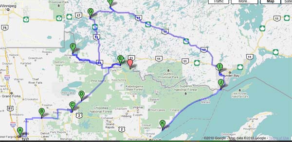
Figure 1: From Blue Lake, Ont., to Two Harbors, Minn.
A=Blue Lake PP; B=Minnitaki; C=Dryden (on Wabigoon Lake); D=Aaron PP (on Thunder Lake); E=Ignace; F=Sandbar Lake PP (gateway to Ontario 599); G=English River; H=Kakabeka Falls PP; I=Thunder Bay; J=Old Fort William; K=Pigeon River PP (all in Ontario).
L=Two Harbors (in Minnesota)
Note the voyageursƒÆ’‚¢ƒ¢-¡‚¬ƒ¢-¾‚¢ trade route along the Pigeon River (K) from Lake Superior to Lake of the Woods,

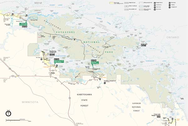
ƒÆ’-¡ƒ”š‚ Figure 2:ƒÆ’-¡ƒ”š‚ Our Tour of Thunder Bay in 1988
A= Terry Fox National Historic Person Plaque: B=Centennial Park;C=Boulevard Lake; D=Hillcrest Park; E=Canada Games Complex; F=International Friendship Gardens; G=Fort William Historical Park.
ƒÆ’-¡ƒ”š‚

Picture 1: The stinging flies of Blue Lake Provincial Park in Ontario marred the idyllic beauty of its scenery.
(Source: Ontario Parks)
ƒÆ’-¡ƒ”š‚
ƒÆ’-¡ƒ”š‚ 
Picture 2: Kakabeka Falls, west of Thunder Bay (2005)(Source: Wikimedia Commons)
December 23rd, 2010 at 6:59 pm
This travel feature contains the wrong maps which don’t fit the two respective captions.
The two maps have already appeared with last week’s travel feature.
December 24th, 2010 at 4:33 pm
Lankaweb has corrected the two errors.
Thank you, and Happy Holidays.