The Travels of a Journalistâ€â€ÂÂ56 – Rural life in southwest Washington fails to impress mother and my sister
Posted on February 16th, 2011
By Shelton A. Gunaratne ƒÆ’-¡ƒ”š‚©2011 Professor of mass communications emeritus@ Minnesota State University Moorhead
ƒÆ’-¡ƒ”š‚ On Saturday (12 Aug. 1989), the day after our tiring tour of Seattle, we were back on the road exploring the backwoods of southwest Washington State along what I designated as the ƒÆ’‚¢ƒ¢-¡‚¬ƒ…-Willapa LoopƒÆ’‚¢ƒ¢-¡‚¬ƒ”š‚ƒÆ’‚¢ƒ¢-¡‚¬ƒ¢¢”š¬‚a route exceeding 250 miles, not counting the side trips. The reason for this insane hurry was the pressure of time to show my mother and my sister a wide spectrum of life in the U.S. before they returned to their respective countries of residence.ƒÆ’-¡ƒ”š‚ Sister ƒÆ’‚¢ƒ¢-¡‚¬ƒ…-RaniƒÆ’‚¢ƒ¢-¡‚¬ƒ”š‚ was to depart from Portland, Ore., Monday (14 Aug.) and my mother the next Monday (21 Aug.).
I have no record of the time we started.ƒÆ’-¡ƒ”š‚ I suppose we set forth late morning considering that we needed several hours of sleep after the midnight arrival from Seattle. About 15 miles west of Longview, on the scenic Ocean Beach Highway (also called SR 4), we stopped at the U.S. Fish and Wildlife Service (1440 Abernathy Creek Road).ƒÆ’-¡ƒ”š‚ But the fish hatchery, which the kids in particular wanted to see, was closed.
Ergo, we drove a further 15 miles south and northwest on SR 4, almost hugging the Columbia River on the Washington side, to Cathlamet (pop. 600), the administrative seat of Wahkiakum County. The greenery of the Douglas firs and other flora on this stretch of the road along the river, the counterpart of U.S. 30 on the Oregon side, was astonishing.ƒÆ’-¡ƒ”š‚ TheƒÆ’-¡ƒ”š‚ (Longview) Daily News had already sent me to Cathlamet on a Wednesday (2 Aug.) to interview Wahkiakum County Councilor Linda Elliott and retired resident Jerry Johnson to write a feature on the six-spot Shay locomotive at the County Historical Museum. The Daily News carried the story on 14 Aug. under the headline ƒÆ’‚¢ƒ¢-¡‚¬ƒ…-Old logging locomotive sashays to new home.ƒÆ’‚¢ƒ¢-¡‚¬ƒ”š‚ I was proud to show the museum to my mother and my sister on this occasion.
I also decided to expand our tour with a visit to Puget Island, an unincorporated rural community of 798 people on the Columbia River. The Julia Butler Hansen Bridge, built in 1938, connects Cathlamet with the 4,785-acre island. We crossed the bridge on SR 409, which enters the islandƒÆ’‚¢ƒ¢-¡‚¬ƒ¢-¾‚¢s northeast and terminates at the Cathlamet-Westport ferry connection on the southwest. The island has a preserve for an endangered species of Columbian white-tailed deer.
Back on the tour route, we stopped for refreshments at Vista Park in Skamokawa (pop. 449), an unincorporated rural village settled by Scandinavian immigrants. It is a local center for fishing and kayaking in Wahkiakum County. Because I had visited this idyllic village 10 days earlier to interview Sharon Hart, director of the Lower Columbia Development Council, I thought it fit to expound my knowledge of the vicinity to my mother and my sister who appeared to be totally unimpressed with my attempts to enlighten them.
For the next 12 miles, SR 4 skirted the Lutes Mountain (1,089 ft.) and Elk Mountain (1,486 ft.) in a northwest direction until it reached Grays River, a small community in the western edge of Wahkiakum County that brags of itself as ƒÆ’‚¢ƒ¢-¡‚¬ƒ…-the home of the oldest covered bridge in the state that still carries a public highway.ƒÆ’‚¢ƒ¢-¡‚¬ƒ”š‚ Built in 1906, the 155-ft. Howe truss timber bridge we saw, however, was uncovered and under restoration.
From thereon, SR 4 follows the contours of the hilly terrain for the next 13 miles. SR 4 descends southward to Grays Bay on the Columbia estuary and then rises northwest to Naselle (pop. 377), a logging town in Pacific County. We visited the fish hatchery in Naselle. Then, we left SR 4, and drove on spur road 401, a 12-mile stretch snaking southward along the cliffs of Bear Mountain (1,010 ft.) and then southwest along the northern shore of the Columbia estuary up to the north terminus of the Astoria-Megler Bridge, which we crossed on 1 Aug. on our tour of NW Oregon. It was lunchtime when we reached the Dismal Nitch rest area, very close to U.S. 101.
As I watched the mouth of the Columbia River at the intersection of spur road 401 with U.S. 101, I congratulated myself for exploring the riparian beauty of this magnificent river from Plymouth, Wash., in the east to its confluence in Astoria-Megler area over an approximate distance of 280 miles.ƒÆ’-¡ƒ”š‚ Moreover, I had seen the scenic splendor of Columbia RiverƒÆ’‚¢ƒ¢-¡‚¬ƒ¢-¾‚¢s final 70 miles from the Oregon angle, as well as the Washington angle.
These thoughts nudged me to move on with our tour plan and continue on U.S. 101 to visit several historical places commonly identified as the Lewis and Clark National and State Historical Parks: two on the Washington side of the Columbia River Confluence and three on the Oregon side.
The first of these we visited was the 593-acre Fort Columbia State Park, off Chinook (pop.ƒÆ’-¡ƒ”š‚ 457). Chinook was once well known for its salmon harvest. The park includes the national historical landmark Point Chinook, from where Capt. Robert Gray spotted the Columbia River in 1792. Fort Columbia is an old coastal artillery post

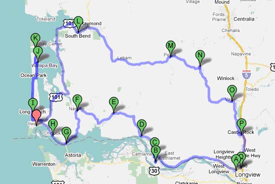
Figure 1: The ‘Willapa Loop’ Tour Route of Southwest Washington (12 Aug. 1989)
A=Longview; B=Puget Island; C=Cathlamet; D=Skamokawa; E=Grays River; F=Naselle; G=Dismal Nitch Rest Area on SR 401, near Astoria-Megler Bridge; H=Chinook/Fort Columbia State Park
Red Arrow=Willapa National Wildlife Refuge (surrounding Willapa Bay) with headquarters @ Ilwaco/Cape Disappointment State Park
I=Long Beach; J=Oysterville; K=Leadbetter Point State Park; L= South Bend; M=Pe Ell; N=Boistfort; O=Vader; P=Castle Rock; Q=Kelso
The second of these we visited was the 1,882-acre Cape Disappointment State Park (formerly called the Fort Canby State Park) on the Long Beach Peninsula, south of Ilwaco (pop. 950). Its facilities include two lighthouses, hiking trails, 27 miles of ocean beach and an interpretive center.ƒÆ’-¡ƒ”š‚ It was good exercise for all of us to walk uphill to reach the interpretive center and the nearest lighthouse. The name of the cape is associated with the disappointment of John Meares, a British fur trader, who missed the credit for sighting the Columbia River because a storm forced his ship to turn around in the vicinity of the cape during one of his scouting forays in search of trade in April 1788.

Cape Disappointment Lighthouse as seen from the North Jetty, Cape Disappointment State Park, near Ilwaco, Washington, USA.(Source: Wikimedia Commons. Photo by Loren T. Vine — ƒÆ’-¡ƒ”š‚ 27 Jan. 2007)
Next, we drove five miles north to Long Beach (pop. 1,283) at the foot of the Long Beach Peninsula. The townƒÆ’‚¢ƒ¢-¡‚¬ƒ¢-¾‚¢s wide stretch of beach was agog with people of all ages who had come to enjoy the sunset. Kids were flying kites and engaged in numerous modes of play. Soon, we too merged into the beach ƒÆ’‚¢ƒ¢-¡‚¬ƒ…-gang.ƒÆ’‚¢ƒ¢-¡‚¬ƒ”š‚ A Good Samaritan, who took pity on Carmel and Junius, passed on a kite to them so they could also enjoy their evening on the beach. Even though it was 6 p.m., we let our two kids fly their bonanza kite until they were tired.

The coast of Long Beach, Wash. (13 June 2007)
(Source: Creative Commons)
From Long Beach, we drove almost 20 miles north on the obelisk-shaped peninsula, along the Pacific Way and Ocean Beach Highway, past Ocean Park (pop. 1,459) and Oysterville (unincorporated), to the Leadbetter Point State Park, south of the Willapa National Wildlife Refuge.
The refuge (with headquarters in Ilwaco on U. S. 101) comprises more than 15,000 acres of tidelands, temperate rainforest, ocean beaches, and small streams. It also includes several rare remnants of old growth coastal cedar forest. The U.S. Fish and Wildlife Service says that the Willapa refuge preserves the habitat for spawning wild salmon, hundreds of thousands of migrating shorebirds, and threatened and endangered species such as the marbled murrelet. The refuge includes two other components outside the peninsula: Puget Island preserve and some 20 islands stretching over 27 miles along the Columbia River from its confluence.
Because the tip of the peninsula was not connected to the mainland by road or ferry across the Willapa Bay, which forms the northern and eastern boundary of the refuge, we had to return to the foot of the peninsula to rejoin U.S. 101 on the ƒÆ’‚¢ƒ¢-¡‚¬ƒ…-Willapa LoopƒÆ’‚¢ƒ¢-¡‚¬ƒ”š‚ (Figure 1).ƒÆ’-¡ƒ”š‚ Fortunately, the charm the excellent scenery that the highway offered all along the Willapa Bay drive from Chetlo Harbor at the mouth of Naselle River to Bay Center at the mouth of Nawakum River kept us all in happy chatter. We saw another view of the Leadbetter Point and the Willapa refuge on the peninsula from the mainland side as our route took a northeast turn at the mouth of Bone River and then a sharp southeastern turn to reach South Bend (pop. 1,807), the county seat of Pacific County.
The summer dusk had set in.
Yoke-Sim, who took over driving at this point, continued along U.S. 101 along the Willapa River to Raymond (pop, 2,895), five miles to the northeast. Then, she turned southeast on SR 6 heading for Pe Ell (pop. 657) in Lewis County, roughly 30 miles away. Vader (pop. 590), the next town in Lewis County, was another 26 miles to the southeast. Between the two towns, we could see the Boistfort Peak (3,120 ft.), the highest point of the Willapa Hills range, to our right.
The ƒÆ’‚¢ƒ¢-¡‚¬ƒ…-Willapa Loop,ƒÆ’‚¢ƒ¢-¡‚¬ƒ”š‚ which we traversed on 12 Aug. 1989, covered a south-north distance of 63 miles from Columbia RiverƒÆ’-¡ƒ”š‚ (south) to Olympic Mountains (north); and a west-east distance of 60 miles from Pacific Ocean (west) to Cascade Range (east). We returned to Longview through Castle Rock (pop. 2,130) in Cowlitz County.
Post Script
Two days later, my sister ƒÆ’‚¢ƒ¢-¡‚¬ƒ…-RaniƒÆ’‚¢ƒ¢-¡‚¬ƒ”š‚ left us on her return trip to Sri Lanka. I still donƒÆ’‚¢ƒ¢-¡‚¬ƒ¢-¾‚¢t know whether she enjoyed the U.S. sightseeing excursions I had put her through.
ƒÆ’‚¢ƒ¢-¡‚¬ƒ…-RaniƒÆ’‚¢ƒ¢-¡‚¬ƒ”š‚ cried when she had to say goodbye to our mother and members of my family. After depositing ƒÆ’‚¢ƒ¢-¡‚¬ƒ…-RaniƒÆ’‚¢ƒ¢-¡‚¬ƒ”š‚ at the Portland Airport, the rest of us stopped at the Gig Creek Rest Area for coffee on the way back to Longview.
The next installment will narrate my motherƒÆ’‚¢ƒ¢-¡‚¬ƒ¢-¾‚¢s first experience in overnight outdoor camping at the age of 76.