The Travels of a Journalistâ€â€ÂÂ57-Mother, 76, learns joy of camping at Illahee State Park in Bremerton
Posted on February 21st, 2011
By Shelton A. Gunaratne ƒÆ’-¡ƒ”š‚©2011 Professor of mass communications emeritus@ Minnesota State University Moorhead
The 75-acre Illahee State Park, a waterfront recreational area that offers camping, hiking and boating to the public, is located in the unincorporated hamlet of Illahee, just north of East Bremerton, on Port Orchard Bay area of the Puget Sound. The park is known for one of its proud possessionsƒÆ’‚¢ƒ¢-¡‚¬ƒ¢¢”š¬‚a 400-year-old evergreen conifer called the Pacific Yew (Taxus brevifolia). “Illahee” means earth or country in the Native American tradition. Washington State purchased the land for the park in seven parcels between 1934 and 1954. Illahee is also home to the 450-acre Illahee Preserve, as well as the 110-acre Rolling Hills golf course.
For me, this scenic spot has significance beyond measure because it was here that my mother, then 76, had her first life experience in outdoor camping.
Illahee/Bremerton lies about 20 miles directly to the west of Seattle, which we explored eight days before. Puget Sound and Port Orchard Bay separated the two cities with Bainbridge Island in the middle. The Seattle (Main)-Bremerton Ferry connected the east-west ends of SR 304 across the sound. The ferry charge makes SR 304 a toll road.
ƒÆ’-¡ƒ”š‚
ƒÆ’-¡ƒ”š‚  |
ƒÆ’-¡ƒ”š‚  |
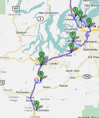
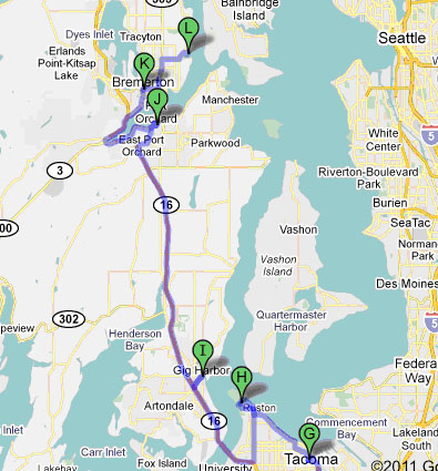
ƒÆ’-¡ƒ”š‚ ƒÆ’-¡ƒ”š‚ ƒÆ’-¡ƒ”š‚ ƒÆ’-¡ƒ”š‚ ƒÆ’-¡ƒ”š‚ ƒÆ’-¡ƒ”š‚ ƒÆ’-¡ƒ”š‚ Figure 1: Route from Centralia to Illahee State Park/Bremerton
A=Centralia; B=Millersylvania State Park/Deep Lake; C=Tumwater; D=Capitol Campus/Olympia; E=Fort Lewis Military Museum; F=Steilacoom; G=Wright Park/Tacoma; H=Point Deviance Park/Tacoma; I=Gig Harbor ƒÆ’‚¢ƒ¢-¡‚¬ƒ”š‚¦(contd. right)
J=Port Orchard; K=Bremerton; L=Illahee State Park/Bremerton
ƒÆ’-¡ƒ”š‚ My mother was not the least bit concerned with any of these geographical details/trivia. Junius and I were very keen to share with her an unforgettable camping experience in our Timberline-4 tent, which we purchased in KelsoƒÆ’-¡ƒ”š‚ (see TravelsƒÆ’‚¢ƒ¢-¡‚¬ƒ¢¢”š¬‚53).
As it turned out, my mother (who was well known as ƒÆ’‚¢ƒ¢-¡‚¬ƒ…-Punchi HamineƒÆ’‚¢ƒ¢-¡‚¬ƒ¢-¾‚¢ in our native village of Pathegama in the Deep South of Sri Lanka) liked her first-ever outdoor camping experienceƒÆ’‚¢ƒ¢-¡‚¬ƒ¢¢”š¬‚the when and where of it didnƒÆ’‚¢ƒ¢-¡‚¬ƒ¢-¾‚¢t mater to her. (She died in Brisbane in her avatar as an Australian citizen at the age of 96 in 2009.) It is for this reason that I opened this essay with a thumbnail sketch of Illahee in the vicinity of Bremerton, Wash. (pop. 37,259) in Kitsap County/Peninsula.
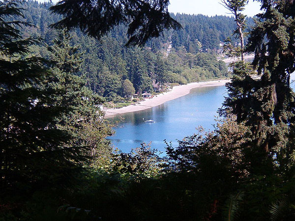
ƒÆ’-¡ƒ”š‚  ƒÆ’-¡ƒ”š‚ Picture 1:ƒÆ’-¡ƒ”š‚ Illahee State Park in the Puget Sound (26 June 2004)
Source: Wikimedia Commons. ]
ƒÆ’-¡ƒ”š‚ Mother joined usƒÆ’‚¢ƒ¢-¡‚¬ƒ¢¢”š¬‚Carmel, Junius, Yoke-Sim and meƒÆ’‚¢ƒ¢-¡‚¬ƒ¢¢”š¬‚on this camping trip on a Saturday (19 Aug. 1989), just two days before she left on her return trip to Australia.ƒÆ’-¡ƒ”š‚ We left Longview at 6.30 a.m. Bremerton was 127 miles to the north in Lewis County.
About 45 miles north of Longview on Interstate 5, we decided to stop at Centralia (pop. 15,699), a town founded by a black slave named George Washington (1817-1915).ƒÆ’-¡ƒ”š‚ A white couple, James and Anna Cochran, adopted Washington, who was born in Virginia. The Cochrans moved west, and successfully invoked a Missouri special right for a black to become a citizen on grounds of his literacy and special skills. Washington was a master rifleman. Subsequently, they moved to Oregon Territory, where Washington was able to purchase land, using the Cochrans as proxies, at the junction of the Skookumchuck and Chehalis rivers. In early 1875, Washington and his wife Mary Jane formally platted the town of Centerville, which was later renamed Centralia.
ƒÆ’-¡ƒ”š‚ Then, we drove another 25 miles north to explore several attractions in and around Olympia (pop. 42,514), the capital of Washington State and the administrative seat of Thurston County. Lushootseed-speaking Native Americans occupied this area for thousands of years before the Europeans arrived in the 1790s. In 1851, Olympia became the customs house for the Customs District of Puget Sound for Washington Territory (originally part of Oregon Territory). Because of the areaƒÆ’‚¢ƒ¢-¡‚¬ƒ¢-¾‚¢s view of the Olympic Mountains to the northwest, the city was named Olympia on the suggestion a resident. Washington became a state in 1889.
We went past the 842-acre Millersylvania State Park, located 10 miles south of Olympia. Deep Lake, a 66-acre freshwater expanse that the Native Americans had named CoKaine Lake, is a big attraction of the park, which provides camping facilities and six miles of trails in the shade of old-growth cedar and fir trees.
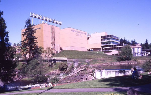
In Tumwater (pop.12, 698), we joined a tour of the Olympia Brewing Co. ƒÆ’‚¢ƒ¢-¡‚¬ƒ…-that we all enjoyed.ƒÆ’‚¢ƒ¢-¡‚¬ƒ”š‚ Olympia beer was the product that came out of the complex that Leopold Schmidt built in 1896ƒÆ’‚¢ƒ¢-¡‚¬ƒ¢¢”š¬‚a four-storey wooden brew house, a five-storey cellar building, a one-storey ice factory powered by the lower falls, and a bottling and keg plant. In 1902, the complex adopted the name Olympia Brewing Co. The Schmidts sold the company in 1982. SABMiller eventually purchased the company. However, Miller closed the plant in 2003. Ag Energy Resources Inc., which purchased the machinery of the defunct company, has transformed the paraphernalia for ethanol production.
 ƒÆ’-¡ƒ”š‚ Caption 2: The Olympia Brewery in Tumwater, Wash. (near Olympia) in 1989.
Source: Wikimedia Commons]
We also visited the Tumwater Historical Park located at the bottom of Capitol Lake, about 2.5 miles south of the capital. The Schmidt House (330 Schmidt Place SW), the home of the beer magnate, is part of this complex.
Thereafter, we drove further north to the city for a quick tour of the Washington State Capitol Historic District. Unlike in most of the states, the executive, legislative and judicial branches of government are not housed in a single Capitol building here. A campus of separate buildings houses the three branches in Olympia.
Our next stop was the Fort Lewis Military Museum, about 15 miles northeast of Olympia. The museum, housed in what was once the Red Shield Inn built in 1919, displayed several collections of uniforms and equipment. A variety of military equipment and weapons occupied the surrounding grounds.
Here, we left I-5 for a five-mile north drive to visit the coastal town of Steilacoom (pop. 6,049) in Pierce County. Our purpose was to see a 1906 soda fountain at the Blair Drug & Hardware Store (1617 Lafayette St.) built in 1895. Founded by Lafayette Balch, a sea captain from Maine, Steilacoom was officially incorporated in1854ƒÆ’‚¢ƒ¢-¡‚¬ƒ¢¢”š¬‚the oldest incorporated town in Washington.
Back on I-5, we headed northeast to Wright Park in Tacoma (pop. 199.638)ƒÆ’‚¢ƒ¢-¡‚¬ƒ¢¢”š¬‚17 miles from Steilacoom. Designed by Bavarian architect Edward Otto Schwageral, this 27-acre park includes an arboretum and the Seymour Botanical Conservatory, a Victorian-style structure built in 1907.ƒÆ’-¡ƒ”š‚ We deemed it apt to be in such pleasant surroundings to savor our late picnic-style lunch,
Then, along the northwest shore of Commencement Bay, we drove six miles to the 702-acre Point Defiance Park, which, all of us agreed, was the star attraction of the vicinity. Just as we saw in similar parks in Portland and Seattle, Point Defiance Park also offered its visitorsƒÆ’‚¢ƒ¢-¡‚¬ƒ¢¢”š¬‚more than 2 million annuallyƒÆ’‚¢ƒ¢-¡‚¬ƒ¢¢”š¬‚its own Japanese Garden, Rose Garden, Rhododendron Garden, and Dahlia gardens. The gardens are located near the park’s main entrance on the approach to the Zoo & Aquarium.
Zoos and aquaria naturally attracted Carmel and Junius. We ambled in the park touching, admiring and smelling the flowers. My mother perked up considerably after this exercise of hobnobbing with nature. The park also accommodates mule deer, red foxes, pleated woodpeckers, Douglas squirrels, and raccoons. So did Carmel and Junius by spotting wildlife as we explored the entire park by driving on the Five-Mile Road loop. From the cliffs overlooking Gig Harbor, we saw bald eagles swooping down on the salmon runs in the Puget Sound Narrows.
ƒÆ’-¡ƒ”š‚ Caption 3: Panoramic view of the Kitsap Peninsula from a lookout on the western cliffs of Point Defiance Park (7 Dec. 2009). The Tacoma Narrows suspension double bridge is on the far left. On to the right are the silhouettes of Olympic Mountains above Gig HarborƒÆ’-¡ƒ”š‚
Source: Wikimedia Commons. Photo by Gregg M. Erickson.]
ƒÆ’-¡ƒ”š‚ We also explored the Fort Nisqually living history museum comprising Factor’s House and the Granary, as well as a trade store, working blacksmith shop, laborers dwelling house, demonstration kitchen, and kitchen garden. This reconstructed fort reminded us of our visit to Fort William Historical Park in Thunder Bay (see Travels-49).ƒÆ’-¡ƒ”š‚
We left the park and crossed the Narrows Tacoma BridgeƒÆ’‚¢ƒ¢-¡‚¬ƒ¢¢”š¬‚a pair of twin suspension bridges opened in 1950ƒÆ’‚¢ƒ¢-¡‚¬ƒ¢¢”š¬‚to sprawling Kitsap Peninsula on SR 16, which took us northward via Gig Harbor (pop. 7,240) to Port Orchard (pop. 7,953).ƒÆ’-¡ƒ”š‚ We rested for a while to view the Port Orchard Marina. I walked in the vicinity visiting several antique and specialty shops.
It was late in the day when we arrived in the shipyard city of Bremerton.ƒÆ’-¡ƒ”š‚ We drove around the city to get our bearings, and found the ideal spot for overnight camping at the Illahee State Park. Junius and I set up the tent on our site and invited my mother to grace it with her presence. She was all too willingƒÆ’‚¢ƒ¢-¡‚¬ƒ¢¢”š¬‚like BarkisƒÆ’‚¢ƒ¢-¡‚¬ƒ¢¢”š¬‚to lie down after a drive of 176 miles all the way from Longview with many sightseeing stops along the way.
ƒÆ’-¡ƒ”š‚ Yoke-Sim prepared a tasty dinner, which we gobbled up seated around the campfire. My mother learnt the pros and cons of using the common rest-room facilities in a public campground. I walked downhill along the shore to enjoy the beach after dark while others got ready to sleep in the tent in their sleeping bags. I chose to sleep in my station wagon so mother could have more tent space.
My mother confessed next morning that she had difficulty having a god nightƒÆ’‚¢ƒ¢-¡‚¬ƒ¢-¾‚¢s sleep in the tent although she relished the overall camping experience.
(Next: Journey to Port Townsend and return trip on U.S.101)
