The Central Hill Country: The ‘Hadabima’ (Heartland) of Sri Lanka A New Geographical Interpretation
Posted on December 2nd, 2017
Sudath Gunasekara. B.A. PhD. (S.L. A. S).
12.12. 2017
Abstract
The Central Hill Country of Sri Lanka is defined as the land above the 300 m (msl) contour that covers roughly about 20% of the total land area of the Island. It constitutes a heavily dissected terrain with spectacular scenic beauty providing the home for a unique biodiversity, both in flora and fauna, endemic and threatened. While serving as the main catalyst in rain making and a climatic regulator for the two Monsoon seasons it also serves as the major watershed that provides the source for almost all the rivers, the live fountains of life in Sri Lanka” with many beautiful waterfalls, in the Island. The World Heritage Convention 2010 also has declared the central Highlands of Sri Lanka as a World Natural Heritage.
In this essay the need for the preservation of this heritage has been highlighted in a broader perspective, both natural and cultural. Its unique geographical value and the critical role it plays in sustaining the watersheds that provide the source for almost all its rivers, which guarantees the survival of the entire life system and the civilization of this Island.
Virtually the hill country has determined and dictated the geographical and cultural landscape of this Island. The physical stability and the natural functions of this central land mass had been the bedrock of our life system and the different facets of civilization through out history. The influence it has exerted on the Island’s geopolitical history as a hideout for Kings and Princes of yore too cannot be overlooked. Therefore it is identified as the most important geographical sub-region that has fashioned both the natural and human landscape on this Island. This situation is a classic example of geographic determinism. A brief reference is also made here to the Mackinder’s Heartland Theory and its evolution in the context of world geopolitics as he was the one who introduced the term ‘Heartland’ to geography.
The role the Central Hill country plays in the survival of the entire life system and the civilization in this country is as critical and important as the role played by the heart in a man’s life. It is primarily in this context that it is named as the ‘HADAMIMA’, meaning The Heartland” of this Island
Introduction
The central hill country of Sri Lanka, a roughly triangular mountainous area located at the south-centra0l part of the Island is defined as the land above the 300 m (msl) contour that covers roughly about 20% of the total area of the Island. Professor K. Kularatnam described it as a veritable palimpsest that displays many facets of geological evolution. With its highest peak at Pidurutalaga, 2,524 m rising above a high plain dotted by few more peaks like Hakgala, Kirigalpotha (2,389 m), Totupolakanda (2,357)m, and Adam’s Peak (2230 m), it constitutes a heavily dissected terrain of rugged mountain ranges, peaks and valleys, and steep escarpments with hundreds of beautiful waterfalls cascading down, the largest number for any given area of its size any where in the world. With its breathtaking scenic splendour the hill country has provided a multiplicity of habitats for many a unique fauna and flora both endemic and threatened. While serving as the major catalyst in rainmaking and a regulator for the two monsoon seasons, it also serves as the major watershed that provides the source for almost all the rivers (103) draining in all the directions in this Island.
The World Heritage Convention which met in Brazil in July 2010 also has declared the Central Highlands of Sri Lanka as a World Natural Heritage. Its unique biodiversity both in fauna and flora of which many species, that are endemic and some of them are threatened was the main criteria the Committee has adopted in making this decision. In this essay the case for the preservation of the Central Highlands in a broader perspective that covers the whole Island. Firstly, taking in to account the totality of its unique geography including the land, forests, fauna and flora and its natural beauty and secondly, the role it plays in preserving the survival of the entire life system and the civilization of this Island. A third, a cultural dimension is also included in view of the religious importance associated with the Adams Peak. All these three factors heavily support the claim for its preservation and to be declared a World Heritage.
The basic argument advanced here is that the Central Highland is a unique creation of nature, with its peculiar morphology, the drainage pattern, the climate, breathtaking scenery and bio-diversity which no other physiographic region of its size in any other country could claim. Both functionally and analogically, it represents the ‘Geographical Heartland’ of this Island as discussed below.
Its south central location within the Island and its relative position with regard to the global wind belts, the altitude, peculiar morphology and the alignment of the mountain ranges and its spatial size in relation to the total land area of the country have played a critical role in the scale and nature of the impact it has exerted on the Islands geography and life system. Virtually it has determined and dictated the geographical and cultural landscape of this country. The climate, drainage pattern, diversity of fauna and flora and the physical and cultural landscape of the entire Island has been decisively influenced by its location, altitude, geology and structure and the alignment of its morphology. The physical stability and the resulting functional role of these central hills had been the bedrock of our life system and the different facets of civilization. It is also the most important and critical factor that finally decides the survival of the entire life system in this country. Therefore the making and the sustainability of both the geographical and the cultural landscape of this Island are critically dependent on the preservation of the physical stability of the high watersheds associated with this region. The influence it has exerted on the Islands geopolitical history by serving as a safe hideout for many Kings and Princes too, both from the Rajarata and the Kandyan Kingdom, cannot be easily overlooked Therefore it is identified as the most important geographical sub-region that has fashioned both the natural and human landscape in this Island. This situation could be cited as a classic example of geographic determinism.
The functional role the central hill country plays in the survival of the entire life system in this country including floral, faunal and human and the country’s civilization is as critical and important as the role played by the heart in the survival of a man. It is primarily in this context that it is cited as the HADABIMA (Hardabhumi) meaning The Heartland” of this Island
The need to protect and conserve this part of the country had been recognized from the earliest times. During the days of the Sinhalese Kings it was declared as a Thanchikele (a protected forest). Eminent men on forestry like Douglus Hooker (1873) and FDA Vincent (1882) of the Indian Forestry Commission who was hired by the then Government to prepare a forestry policy for Sri Lanka (the father of modern forestry policy) also have strongly recommended the conservation of forest lands over 5000 feet. Even the forestry policy approved by the government in 1995 states that all the forest areas are to be managed in a sustainable manner, though no one has taken such advice seriously up to date.
According to the Report of the Land Utilization Committee 1968 the area > 5000 ft in the Island is 288 sq miles. Of this 187 square miles are found within the Nuwara Eliya district, Kandy district 47, Badulla dist 38 and Ratnapura and Kegalle 16. There are 120 sq miles > 6000 feet. Of this 94 sq miles are found in Nuwara Eliya and 8000 acres of tea are found on land > 6000 ft msl. This shows the magnitude of the devastation tea plantations have done to the central highlands.
Even Sir Henry Beresford, Director General of Forestry United Kingdom, giving evidence before the Land Utilization Committee has pointed out the need for preserving the forests of land above 5000 feet elevation where virtually all rivers have their origin as a matter of absolute necessity. This will enhance the dry weather flow of all rivers in the Island and also improve the ground water resources he said. The best way to restore the water resources and the ecological balance in the country, particularly the central highlands is to restore the original forest cover of the central hills above 5000 feet msl. As such the declaration of all lands over 5000 feet therefore is long overdue.
The origin of the Heartland Concept and its meaning
The concept of a ‘heartland’ had been in vogue in many countries from ancient time. It was usually associated with a core area in a given Kingdom where the capital was located It connotes many meanings such as central, most important, most prosperous and most powerful etc which are closely interlinked. Very often the capital city of a Kingdom was identified as the Heartland of that country. As such from the beginning of history the term heartland often implied a geopolitical meaning. In the modern context also it implies mainly a geopolitical notion. Geopolitics in its modern sense indicates the link and causal relationships between the centre of political power and geographic space in a given Kingdom. Therefore it could be surmised that even this ancient notion, the heartland had a geopolitical connotation
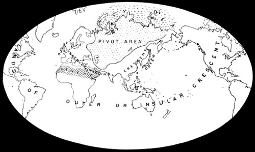
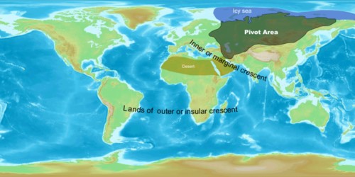
The term geopolitics was coined at the beginning of the 20th century by Rudolf Kjellén, a Swedish political scientist, inspired by the German geographer Friedrich Ratzel, whose book Politische Geographie (political geography) that was published in 1897. But the Heartland concept was first used by Sir Halford John Mackinder (1861-1947) in 1904 to conceptualize a geopolitical idea in an article named ‘The Geographical Pivot of History’ submitted to the Royal Geographical Society. Mackinder was an English geographer and one of the founding fathers of Political Geography and Geopolitics. He used the term ‘Heartland’ purely in a geopolitical context to designate a part of the Asian landmass what he described as the Pivot Area.
In his exposition he divided the world in to three parts
1 The world Island; Europe, Africa and Asia
2 The Offshore Islands; British Isles and the Island of Japan
3 The Outlying Islands; North America, South America and Australia. (Map1& 2)
Map1
After Mackinder 1904
Map 2
After Mackinder 1904
He named the land east of Volga to the Yangtze and from the Himalayas to the Arctic as the ‘Heartland’. This he also called the Pivot area.
He then summarized his theory as:
Who rules East Europe commands the Heartland;
Who rules the Heartland commands the World Island;
Who rules the World-Island controls the world”.
It is evident from this brief account that Mackinder’s Heartland theory was an outright geopolitical concept and was a very ambitious idea that covered the entire globe. It was also an abstract and sweeping generalization formulated by him based on the then prevailing global geopolitical situation and power structure. He had not taken in to account possible changes that would occur in future in military, technological, the world economic and power politics. Therefore it had the inherent weakness of non-congruence with changes in time and space. As such some people consider Mackinder’s theory as obsolete in the present context.
Inspired by this hypothesis Karl Haushofer and Hitler of the Third Reich attempted to take control of the Heartland, during the Second World War, with the idea of world domination. As we know they failed in their mission and today it is only a part of history now. Subsequent developments in technology, navel and air power and the art of war as well as the decline of political and economic supremacy of Europe and the emergence of new core areas of economic and political power, such as USA, Japan and China, have largely disproved the validity of this theory. Still later people like Samuel Huntington in his notion of the clash of civilization and Dimitri Kitsikis in his “Intermediate Region” have given new dimensions to this concept.
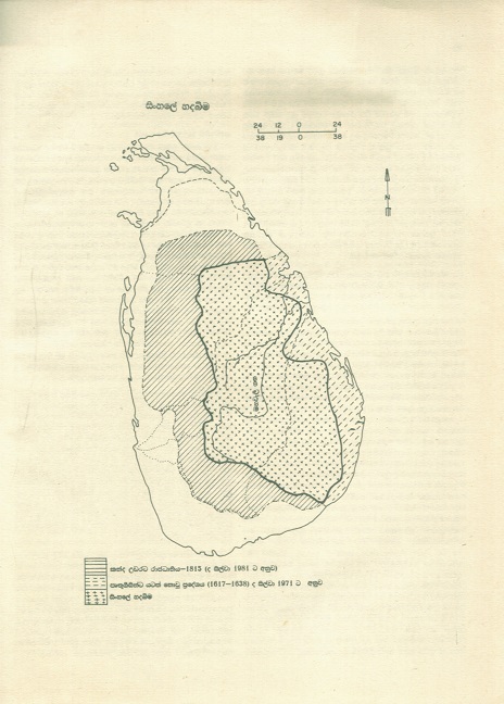
Professor C.M.Meddumabandara in 1984 also attempted to replicate the Mackinder’s heartland theory to a section of the Kandyan Kingdom partly covered by the Mahaweli River in an article ‘Mahaweliya Saha Sinhale Hadabima’ published in Vol.1 Mahaweli Vansaya. His approach seems to be more historical. According to him the area that afforded the Sinhalese to live as an independent nation before the advent of the British in 1815 is called Hadabima of the Sinhale. He argues that this land area was spread around the Mahaweli Basin. But firstly, the area named in his map as Hadabima (map 3) extents far outside the Mahaweli Basin even extending up to Kataragama in the South East. Thus there is a geographical overlap. Secondly it is also not identical with the Kadyan Kingdom as it was in 1815. Therefore his argument lacks consistency and appears to be irrelevant and not logical. Both these propositions therefore appear to be sweeping statements, imaginary and less realistic both in terms of time and space.
(Map 3)
Mahaweliya Saha Sinhale Hadabima
HADABIMA concept and the Central Highlands of Sri Lanka
The proposition discussed in this paper on the other hand is related to an actual situation on ground. The boundaries are clearly defined and not vague as in the previous two cases. Therefore it is realistic and more logical. It also has not been conceived by anyone else before. Unlike Mackinders theory and the Maddumabandaras proposition the validity of my concept will also not change over time unless some major changes in the physical characteristics of the Hill Country take place due to tectonic movements resulting in an upliftment or a subsidence of the Central Highland or a shift of the global wind belts occur due to a change in the inclination of the earth’s axis in relation to the plane of its orbit. Therefore its validity will remain as long as the present physical conditions[1] of the hill country and the position of the earth remain undisturbed.
Although the author too had been exposed to Mackinder’s Heartland Theory, this concept was not directly based on his proposition, though the term HADABIMA connotes heartland in English. The term Hadabima is used to designate a definite unit of Land mass clearly positioned and marked on the map of Sri Lanka. Therefore it is an independent notion conceived to interpret the Sri Lanka situation per se. Unlike in Mackinder and Maddumabandara the term Hadabima in this context is used in a much broader perspective to name the Hill Country without limiting it to a mere geopolitical or a historical interpretation, as already outlined in the opening paragraphs of this article
This concept is discussed under three perspectives
1 Location of the Hill Country at the centre of the country in relation to the spread of the land mass of the Island
2Close analogy between the morphology of the central Hill country and the blood circulatory system
3The affinity between the functions of the blood circulatory system and the physical functional process of the Central Hill Country
Morphological
Secondly, if you look at the physiographic map of the central hill country of Sri Lanka after turning it by about fifteen degrees clockwise until you position Rakwana hills on the west and Dumbara hills (Knuckles) on the east and, superimpose the blood circulatory system, you will notice that by way of analogy, broadly it resembles a sketch of a diagram of a ˜HEART. The Central massif flanked by the two ‘LUNGS’, Rakwana and Dumbara (Knuckles) hills on either side resembles a veritable ˜HEART”[2] (Map 5). To this extent the morphological outline of these three land masses together represents a veritable replica of a heart with two lungs on either side.
Map 4
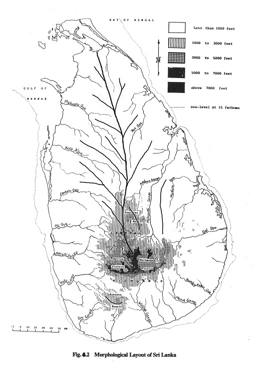
Map 5
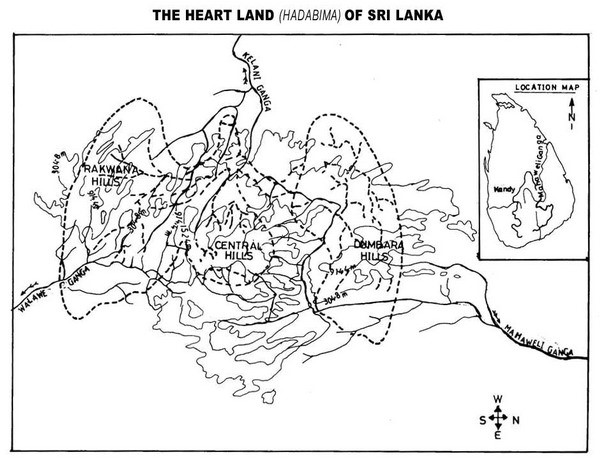
Source: Sudath Gunasekara, 1991
Functional
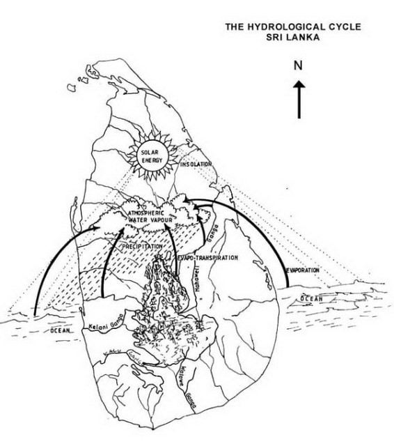
Thereafter it is compared with the map showing the river basins of the Island. Within this broader perspective then one could visualized the rivers starting from the centre as a network of veins and arteries that carry the ˜blood” which is purified and returned back to the heart through the process that operates via the hydrological cycle. The analogy could be clearly verified and observed by superimposing the blood circulatory system of a human over the morphological map of the central highlands in this position along with the map showing the river basins of the whole Island (Map 5). This could be further verified by comparing this situation with the map depicting the hydrological cycle operating over Sri Lanka. (Map 7). In this position you will notice that by way of analogy the central hill country of Sri Lanka also resembles an important segment of the hydro-circulatory system that is very much similar to the heart in the blood circulatory system that we see in a human body. This adds a second dimension, a functional analogy to the physical process that is in action on these high lands.
Map 6

Source: Hydrological Survey Department
The Central Hill Country also provides the source for all the rivers in the Island. Out of a total of 103 rivers, nearly forty have their sources directly on these high watersheds. Even the other streams in the Island owe their origin and the courses to the broader foundation of land forms set by the underlying geological structure of the central high lands. Draining down the hills and the coastal lowlands all around sculpturing the landscape and feeding the whole country with their bountiful water resources, the rivers form the live ‘veins and arteries’ that keep the Islands entire life system alive.
The rivers transport the excess water that falls from the heavens together with the water released by the sub-surface in to the high seas. The forest cover and the sub-surface absorb part of the rainfall. The forest cover and the water bodies also transfer a part of the rainfall received by them back to the atmosphere by way of evapo-transpiration. Together with what is evaporated from the ocean the same rain water that falls from the heavens thus returns as rain through the process of evaporation and precipitation activated by solar radiation and atmospheric circulation. Once again the excess water is transported back to the seas by the rivers. This we call the hydrological cycle. (Map 7)
Source: Sudath Gunasekara. 1991
If you observe this process carefully you will see a close affinity between this circulation and the blood circulation in a human body. As much as the heart does the purification and pump out purified blood and receive unpurified blood via the veins and arteries and keeps the being alive the central hill country also technically does its ˜purification and ˜pumping out and in water with the help of rivers, vegetation, the ocean, and the hydrological cycle and keeps the ‘body Sri Lanka’ alive and thereby guarantee the entire life system in the Island. Thus functionally too, it resembles a heart.
If these rivers cease to flow in their sources due to deforestation, land degradation or any other reason, they will also cease to flow in their entire lengths and as a result the above functional process will also come to an end. Then logically the country will turn in to a desert. Then the entire life system on this Island will disappear from its surface. This will draw the curtain on the Islands civilization as well.
Accordingly, just as the beat of the heart decides the fate of a being, even so, the proper functioning of the hill country that in turn depends on its physical and hydrological stability, will decide the fate of the entire life system in this country. The day the hill country stops its normal functioning, the beginning of the end of the Islands entire life system will firmly set in. Therefore just as the heart is the most important life-giving organ in the human anatomy, in the same way, the Central Hill Country is the prime life-giving agent (Hadabima) of the body that is Sri Lanka.
The heart is the most crucial organ of a man. The beat of the heart decides his fate. Similarly the physical stability and the proper natural functioning of the Central Highlands are equally critical in deciding the survival of the entire life system in this Island. It is in this backdrop the central hill country is named as the Heartland” of Sri Lanka.
The approach adopted in this proposition is primarily geographical with emphasis on it as a watershed that decides the fate of the nation. However it also embraces a broader field and takes in to account the impact of the hill country on other aspects like geopolitics, environment, history, climate, agriculture and fauna and flora in the Island as well.
Besides the Islands relatively small size and its geographical location in relation to the global wind belts and the upper atmospheric circulations, location of the hill country and its peculiar physiography as a watershed have heavily influenced the rainfall pattern and the drainage pattern that has a critical impact on the life system of the Island.
Biggest natural reservoir
It also acts as a giant natural reservoir or a mega sponge that retains millions of gallons of water both underground and over ground. The underground deposits recharge the rivers and make them perennial, besides sustaining the forest cover on the watersheds. The central hill country also plays a vital role in rainmaking and also functions as a climatic regulator. This is a unique situation for any country in the world. The central hill country with its forest cover in fact could, therefore, be described as the Islands biggest natural reservoir and the most important natural asset that sustains the water resources of this country.
If you consider the quantum of water that is stored by a grown up tree, one can imagine the enormous volume of water that would be stored by the forest cover alone that envelopes these watersheds spanning over 20% of the Islands total area that is almost 13,000 square kilometers. These watersheds also store an enormous volume of water in its underground layers, which helps to recharge the entire drainage system of the Island. The springs, that spring up, right round the hill country, would not have been there, if not for these central hills. They also make the rivers perennial. Thus, the hill country maintains both the physical and hydrological stability of the central watersheds, the most crucial factor in sustaining the Islands life system. The physical stability of the Central Hill Country is particularly important in sustaining the perennial water resources of the Island
The forest cover on these watersheds acts as a protective umbrella for the hill country. Besides sustaining the physical and hydrological stability of the Island, they also protect and enrich the surface soil layer, biodiversity and maintain the ecological balance. More trees on the one hand mean less surface run-off, less erosion, less earth slips and less flashfloods and less siltation in riverbeds and down stream areas. On the other hand more trees also means more rain, more water, higher water table, a better soil layer, better irrigation and higher hydroelectricity potential, cheap power, more fauna and flora, optimum ecological balance, more crops, better agriculture, more industries, more employment, more people and finally better and higher standards of life for the people. An unprotected, degraded and barren hill country on the other hand will leave us with rivers without water, powerhouses without power and finally, a land without all these assets.
The day the forest cover is no more on these hills, the rain that falls on it will run down to the sea within few hours or even few minutes, churning up the soil layer and exposing the bed rock. The rivers will also cease to be perennial; their cascading beautiful waterfalls will disappear and the heartland will stops all its normal functions. The day the heartland stops its normal functions, water resources will get depleted and the curtain will fall on the survival of the entire life system and finally on the civilization of this Island. It is in this logical perspective that we should try to understand the critical importance of protecting the central hill country as the country’s Geographical HADABIMA” with the same care and caution that we take to protect our own hearts.
“Those who protect the forests that envelope the HADABIMA protect the Islands watersheds.
Those who protect the watersheds will protect the ‘fountains of the nation’s water resources’ along with the springs, streams and rivers arising there from, and also the soil and the entire life system thereon.
Those who protect the fountains of the nation’s water resources including its watersheds, springs, streams and rivers will also protect the totality of the life system and the civilization on this beautiful Island.”
Post script: The word “HADABIMA” is commonly used today in Sri Lanka to designate the former NADSA project; which is now called the HADABIMA Authority of Sri Lanka. It is also widely and popularly used by geographers, nature lovers and journalists, to describe the central hill country. But unfortunately very few people know the history behind the origin of this word. As such I must mention it here for record purposes that it was I who coined this word in 1991 to describe the Central Hill Country and renamed the National Agricultural Diversification and Settlement Authority (NADSA) Project. In respect of the NADSA project it means Haritha Danav Bim Sanvardhana Madhyama Adikariya; (Hadabima Authority: The Green Habitat Development Authority of Sri Lanka). But in respect of the Central Hill Country and the Island at large it simply means the Geographical Heartland” that decides our future survival on this Island Nation.
What motivated to look for a new name for this Project was also interesting. The NADSA Project, started in August 1978, dealt with Watershed Management, Settlement Development and Agricultural Diversification of marginal tea and rubber lands in the mid-country (300-900 feet msl). The people involved with this Project were landless poor rural peasants from the neighboring Kandyan villages. The word NADSA did not mean anything to them. It was also beyond their comprehension and alien to their emotions. In fact when I took it over in April 1986 it was already dead and the government had decided to close it down. Therefore it was difficult to get even the few settlers, who still had not left their allotments, motivated and inspired to give their best and total commitment to development. When I decided o give a new lease of life to this project I strongly felt for the need to invent a new mechanism and strategy that could inspire and motivate people around it in order to make them active and vibrant partners of development. Among many other strategies developed, the search for a new name for the Project, was on the top of my priority list. The word HADABIMA was the result. The new emotional and psychological feeling thus generated with the magic word HADABIMA inspired the people to feel that the Project area was like their heart. It really worked like a miracle. The message given to the settlers through the new name Hadabima therefore was that they should protect the Central Hill Country as if they are protecting their own hearts, not only for their own benefit but for the benefit of the whole nation and also the salvation of the whole country from an imminent nemesis in the foreseeable future.
I felt this message was relevant then, only to those settlers involved with the HADABIMA Project. But today I am convinced that it is relevant, more than ever before, to every man, woman and child in this country including those who are yet to be born.
(I suggest that this message be introduced to all the children in this country at school level, to be by hearted and observed as a sacrosanct ‘religion’, so that they will not make a mistake in their mission to preserve and leave the heritage they have inherited from mother nature and their forefathers, that is Sri Lanka for the benefit of the future generations)
References
- Professor Kularatnam K. (1954) The Face of Ceylon’ 9th Association of the Ceylon Advancement of Science
- Mackinder, H.J. Democratic Ideals and Reality. Washington DC. National Defense University Press 1996 Pp175-194.
- Wikipedia, The True Encyclopedia-Jump to Navigation Search
- Huntington Samuel, Clash of Civilization and the Remaking of the World Order 1997.
- Gunasekara Sudath. The Central Hill Country; Geographical Heartland of Sri Lanka. Concept Paper. 1991
- Maddumabanda, C.M. ( 1984)‘Mahaweliya Saha Sinhale Hadabima’ Vol.1 Mahaweli Vansaya
[1] Note:
Extreme caution has to be taken not to upset nature by constructing large reservoirs like Kotmale on these high watersheds. Because, as I have pointed out some time back to the President of this country, one day if there is going to be a dam breach at this level the resulting downstream devastations would be devastative and unimaginable.
[2] In fact this was accidentally discovered one day as the author was examining the physiographic map of the Central Hill country as a student of geography, since these two mountain zones, Rakwana and Dumbara had always appeared as two outliers flanking the central massif at the center as two guards resembling lungs.
December 2nd, 2017 at 4:30 pm
Thank you Sudath.
The British destroyed the heartland of the nation ecologically and demographically. Catchment areas and near catchment areas were colonized by South Indian slaves destroying the ecological balance. Tea industry makes no gains for Sri Lanka today. It keeps destroying the nation while making profits for various South Indian communities in the island.
December 3rd, 2017 at 1:46 am
In the years and decades to come, fresh water is going to be real currency world over. If we begin with allowing tea land to return to forest and bring back our fresh water supply. Our fresh water can be a revenue earner bypassing many times over the destructive tea plantations that continue wash our mountains, resulting in land subsidence and land slides and in the end silt our river systems.
Rivers that used to carry fresh clear water before the advent of the murderous British now carry the lifeblood of our land the topsoil to sea creating – now an annual event the floods.
Dr Sudath this is a timely call, to save our heartland for us and for future generations. Thank you.
December 3rd, 2017 at 5:33 am
Traitor anti Sinhalese, anti Buddhist, anti Sri Lanka catholic run UNPatriotic party has destroyed up country as well.
Under Sirima Shastri pact 650,000+ estate tamils were prepared to go back to tn. Then Sirima lost elections and
traitor alugosuwa (to Sinhalese only) thambi mudiyansela jr@ came to power and gave citizenships to all of them
who were prepared to go back for their votes. Now they are ardent supporters of tamil drealam and have
aspirations for their own drealam. That’s how these traitor UNPatriotic party destroys everything for the Sinhalese race and Sri Lanka.
Only recently traitor chief die hard catholic token Buddhist Bay Gal Karaya
Mega Thief Mega Thakkadiya Batalande Wadakaya Pol Pot r@nil wickrama Sinhala killer gave deeds to land to over 2,500 estate tamils to expedite the creation of upcountry tamil drealam. Traitor Sinhala modayas who support these
out and out anti Sinhalese, anti Buddhist, anti Sri Lankan UNPatriotics, open you eyes, have at least one brain cell
in your head to understand these thakkadiyans’ treachery and wipe out these murderous (Sinhalese blood only), thieving traitor kala kannis from the face of Mother Lanka!
December 5th, 2017 at 4:40 am
To Preserve WATER, Preserve the Hill Country.
December 5th, 2017 at 4:44 am
Sudahth are you talking about Malay Nadu. That is what the Indian Empire calls it. Modi confirmed it in his last visit.
December 6th, 2017 at 7:09 am
2,500 estate tamils to expedite the creation of upcountry tamil drealam- Another West bank !
We-Tamils only asked one TE but You Sakodarayas(You know what I mean) gave us Three TE ( Saiva TE/ Muslim TE/ Malaiyaka TE)