The Travels of a Journalistâ€â€ÂÂ15-TIKI-TOURING NEW ZEALAND: EXPLORING THE EAST OF SOUTH ISLAND
Posted on March 2nd, 2010
By Shelton A. Gunaratne c 2010
In New Zealand, the West (in the sense of Horace GreeleyƒÆ’‚¢ƒ¢-¡‚¬ƒ¢-¾‚¢s ƒÆ’‚¢ƒ¢-¡‚¬ƒ…-Go West, young manƒÆ’‚¢ƒ¢-¡‚¬ƒ”š‚) refers to the West Coast of the South IslandƒÆ’‚¢ƒ¢-¡‚¬ƒ¢¢”š¬‚the area to the west of the Alpine range that you can penetrate through the Haast Pass on Highway 6, ArthurƒÆ’‚¢ƒ¢-¡‚¬ƒ¢-¾‚¢s Pass on Highway 73, or Lewis Pass on Highway 7. The 600 km coastal strip between Kahurangi Point in the north and Awarua Point in the south encompassing an area of 23,336 square km is called the West Coast. With only 32,800 people, it is the most sparsely populated region of New Zealand.
Our West Coast tour of the Tiki Tour guided by our ƒÆ’‚¢ƒ¢-¡‚¬ƒ…-steerologistƒÆ’‚¢ƒ¢-¡‚¬ƒ”š‚ Merv Papakura terminated when we crossed the Haast Pass to the Otago region. Now, Papakura was guiding us through what I call the East of the South Island (meaning, all other regions except the West Coast).
Thursday (17 Dec.) morning, with a pleasant sunshine greeting us, Papakura transported us to see a few more attractions in QueenstownƒÆ’‚¢ƒ¢-¡‚¬ƒ¢-¾‚¢s vicinity: the Cattledrome; the Coronet Peak Ski Grounds; and Arrowtown (20 km northeast), where Yoke-Sim purchased a sheepskin for $279.ƒÆ’-¡ƒ”š‚ We returned to Queenstown for lunch. I ate pancakes on the mall while Yoke-Sim shared a soup with Junius.
Heading for Milford Sound
In the afternoon, Papakura took us off to our next destination, Te Anau (population 2,000) in the Southland region, 171 km southwest of Queenstown. We drove south on Highway 5 along the eastern bank of Lake Wakatipu to its southern tip at Kingston, where we crossed from Otago to Southland region.
We continued going south up to Five Rivers, where we turned into Highway 97, a shortcut route going southwest to Mossburn. After stopping there for refreshments, we proceeded northwest on Highway 94 all the way to Te Anau, located on the southeastern tip of the 65 km long Lake Te Anau, the second largest lake in New Zealand after Lake Taupo. Te Anau serves as the gateway to the Fjordland National Park, the eastern boundary of which includes Lake Te Anau.ƒÆ’-¡ƒ”š‚
We checked in to the Vacation Hotel for two nights. After dinner, Yoke-Sim and Junius joined me for a walking tour of the town. Back in the hotel, I was thinking of the next dayƒÆ’‚¢ƒ¢-¡‚¬ƒ¢-¾‚¢s visit to Milford Sound when Junius interrupted my reverie by accidentally smashing my eyeglasses.
In the morning, we drove 117 km northwest on Highway 94 to visit the Milford Sound, located almost on the northern boundary of Fjordland National Park. Here we were not too far (as the crow flies) from the northern tip of Lake Wakatipu, just across the Alpine barrier.
Milford Sound (fjord) is considered one of the worldƒÆ’‚¢ƒ¢-¡‚¬ƒ¢-¾‚¢s topmost tourist attractions with about 1,500 people visiting it every day. (Wikipedia explains that sound or seaway is a large sea or ocean inlet larger than a bay, deeper than a bight, wider than a fjord, or it may identify a narrow sea or ocean channel between two bodies of land called a strait).
We rested for a while at the Milford Hotel before boarding the boat Mitre Peak 2 for the two-hour Milford Sound experience along the fjordƒÆ’‚¢ƒ¢-¡‚¬ƒ¢-¾‚¢s 15 km run inland from the Tasman Sea. I lay snugly on the boat relishing a chicken and Champaign lunch as I observed
ƒÆ’-¡ƒ”š‚ sheer rock faces that rose 1,200ƒÆ’-¡ƒ”š‚ meters (3,900ƒÆ’-¡ƒ”š‚ ft) or more surrounding the inlet on each side. I saw the peak The Elephant at 1,517ƒÆ’-¡ƒ”š‚ meters (4,980ƒÆ’-¡ƒ”š‚ ft), resembling an elephant’s head; and the peak Lion Mountain, 1,302ƒÆ’-¡ƒ”š‚ meters (4,270ƒÆ’-¡ƒ”š‚ ft), resembling a crouching lion. I saw the lush rain forests clinging precariously to these cliffs, while seals, penguins and dolphins danced and pranced in the waters. An occasional whale too might have appeared.
ƒÆ’-¡ƒ”š‚ (Post-tour note: On 8 Feb. 2004 a spill of 13,000 liters of diesel fuel was discovered, resulting in a 2-km oil spill, which closed the sound for two days.)
We returned to our hotel in Te Anau late afternoon. After dinner, Junius, Yoke-Sim and I took a boat ride to the Glow-Worm Caves, 14 km away on the western shore. Junius, whom I was carrying strapped on to my back, cuddled on to me and closed his eyes as we explored the dark grotto. The chorus of the American popular song of the 1950s crossed my mind:
Shine, little glow-worm, glimmer,
Shine little glow-worm, glimmer!
Lead us lest too far we wander.
Love’s sweet voice is calling yonder!
Dinner in Dunedin
Saturday (19 Dec.) morning, we left Te Anau on the 290 km trip to Dunedin (population 115,700), the administrative center of the Otago region. PapakuraƒÆ’‚¢ƒ¢-¡‚¬ƒ¢-¾‚¢s plan was to drive on a southeast direction on Highway 94 up to Gore and then drive northeast to Dunedin on Highway 1. We crossed back to Otago region from Southland at Arthurton on Highway 1.
On the way, we stopped at Lumsden to visit the 700-acre Timbertop Sheep Farm. The farmer-in-charge gave us a talk on sheep farming and also provided a demonstration of sheep sheering. Junius had the distinct privilege of bottle-feeding a baby sheep that a farm girl introduced while we all helped ourselves to refreshments. (See picture)
Our lunch stop was Peggydale, three km south of Balclutha. We had a chat with Bill, Peg, Mervyn and Alison Jones, who operated the Peggydale Tourist Center. Yoke-Sim bought a cardigan here. Peg gave Junius a souvenir and told me about a Sri Lankan living in the area. (Google maps have wiped out Peggydale although the place still exists.)
In Dunedin, we stopped to see the glory of Overton House, an old home built by an idealist from Bristol in the inner suburb of City Rise, which is notable for its grand townhouses dating back to late 19th century.ƒÆ’-¡ƒ”š‚
We checked in at the Southern Cross Hotel (118 High St.), where our tour group had their first formal dinner. Thereafter, I walked alone to Belleknowes Parkland (now converted to a golf course) via York Place and returned via Russell Street.
Mt. Cook Overnight
SundayƒÆ’-¡ƒ”š‚ (20 Dec.) morning, we moved from Otago back to Canterbury region, where we set forth on this long excursion nine days ago. PapakuraƒÆ’‚¢ƒ¢-¡‚¬ƒ¢-¾‚¢s directions were to take his Tiki Tour group to enjoy their final night on the South Island at the Aoraki/Mount Cook National Park, situated near the town of Twizel some 220 km to the northwest of Dunedin. Accordingly, we left the Southern Cross after breakfast heading north on Highway 1 passing through some of the cityƒÆ’‚¢ƒ¢-¡‚¬ƒ¢-¾‚¢s landmarksƒÆ’‚¢ƒ¢-¡‚¬ƒ¢¢”š¬‚like the Dunedin Hospital, the University of Otago campus, and the Botanic Gardens. We stopped for tea at Oamaru (population 13,000), 113 km north of Dunedin. It is the largest town in north Otago, and is the eastern gateway to the Mackenzie Basin, via the Waitaki Valley. We went to a hilltop to get a good view of Oamaru and the Pacific coast below.
Then we headed northwest to the Waitaki Valley and crossed over to Canterbury region about 40 km away, near Duntroon. After Kurow, we went past a succession of lakesƒÆ’‚¢ƒ¢-¡‚¬ƒ¢¢”š¬‚Waitaki, Aviemore, and BenmoreƒÆ’‚¢ƒ¢-¡‚¬ƒ¢¢”š¬‚until we reached Omarama, our lunch stop.
This is where highways 8 and 83 merge to climb up to the foot of Lake Pukaki, where they separate again, one (Mt. Cook Road 80) going north to the Mount Cook Village (where we were heading), the other (Tekapo-Twizel Road 8) going east.
We continued our climb past Clearburn to the town of Twizel, where we stopped at the Information Center to watch a film on the hydro-electric scheme combining four lakes in the area. Thereafter, we climbed up the road going north alone the western shore of Lake Pukaki and crossed Birch Hill to reach the Aoraki/Mount Cook National Park, of which the Mount Cook Village is a part. We checked in at the Glencoe Lodge, now a wing of The Hermitage.
ƒÆ’-¡ƒ”š‚ The A/MCNP comprises an area of more than 700ƒÆ’-¡ƒ”š‚ square km. ƒÆ’-¡ƒ”š‚ Glaciers make up 40 percent of the park area, notably the Tasman Glacier on the slopes of Aoraki/Mt Cook. All of New Zealand’s 20 peaks higher than 3,000 meters, except Mount Aspiring, lie in this national park, which bears the name of New Zealand’s highest mountain, Aoraki/Mt Cook (3,753 meters).
The Mount Cook Village lies 12 km south of Aoraki/Mount CookƒÆ’‚¢ƒ¢-¡‚¬ƒ¢-¾‚¢s summit. The Hermitage is the villageƒÆ’‚¢ƒ¢-¡‚¬ƒ¢-¾‚¢s easiest locator. In fact, we were now not too far from the glacier region of the West Coast. As a satellite map would show, the Haast Pass was incredibly close to where we were.
Unfortunately, rain spoilt our evening. Rain made everything surrounding us virtually invisible.ƒÆ’-¡ƒ”š‚ With many activities canceled, the only thing I could do was to eat our dinner, and walk to the Visitors Center on Bowen Drive and The Hermitage on Terrace Road. But there was a happy event too:ƒÆ’-¡ƒ”š‚ Yoke-Sim and I noticed that Junius could get out of the cot by himself!
On Monday (Dec. 21) early morning, Yoke-Sim and I (with Junius strapped on my shoulders) climbed up to The Hermitage and took photos with New ZealandƒÆ’‚¢ƒ¢-¡‚¬ƒ¢-¾‚¢s highest peak in the background.
However, the drizzle, the rain, and the mist prevailed most of the day as Papakura took us on the 333 km journey from the Mount Cook Village back to Christchurch. At the foot of Lake Pukaki, we turned east on Highway 8 and stopped at the dog-shaped Lake Tekapo for refreshments. Our lunch stop was Geraldine, where I had the time to make a quick trip to the public library.
We arrived in Christchurch just after 3 p.m. We thanked our ƒÆ’‚¢ƒ¢-¡‚¬ƒ…-steerologistƒÆ’‚¢ƒ¢-¡‚¬ƒ”š‚ Merv Papakura for his tireless service over the last nine days. Having thus terminated the South Island Tiki Tour, Papakura took the tour group members continuing on the North Island leg of the tour to the Christchurch Airport to fly to Wellington.
ƒÆ’-¡ƒ”š‚ Next: Tiki Touring the North Island
(The writer is a professor of mass communications emeritus, Minnesota State University Moorhead.)
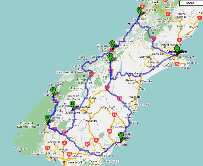
Figure 1: The route of our South Island Tiki Tour of New Zealand: A/I= Christchurch; B=Greymouth; C=Franz Josef; D=Queenstown; E=Te Anau; F=Milford Sound; G=Dunedin; H=Mt. Cook National Park.We covered more than 2,111 km.
 ƒÆ’-¡ƒ”š‚
Picture 1: At the Timbertop Sheep Farm in Lumsden, Otago, on Saturday, 19 Dec. 1981: The writer helps himself to mid-morning tea while his son Junius and wife Yoke-Sim try to bottle-feed a baby sheep introduced by a farm girlƒÆ’-¡ƒ”š‚

ƒÆ’-¡ƒ”š‚
ƒÆ’-¡ƒ”š‚ ƒÆ’-¡ƒ”š‚
ƒÆ’-¡ƒ”š‚ ƒÆ’-¡ƒ”š‚
ƒÆ’-¡ƒ”š‚
ƒÆ’-¡ƒ”š‚
ƒÆ’-¡ƒ”š‚
ƒÆ’-¡ƒ”š‚
ƒÆ’-¡ƒ”š‚
ƒÆ’-¡ƒ”š‚
ƒÆ’-¡ƒ”š‚
ƒÆ’-¡ƒ”š‚
ƒÆ’-¡ƒ”š‚
Yoke-Sim and I (with JuniusƒÆ’-¡ƒ”š‚ on my arms) climbed up to The Hermitage in the Mount Cook Village early morning on Monday 21 Dec. 1981. They were just 12 km from the highest peak in New Zealand, Aoraki/Mount Cook (3,753 meters), in the background.
")
ƒÆ’-¡ƒ”š‚
ƒÆ’-¡ƒ”š‚
ƒÆ’-¡ƒ”š‚
ƒÆ’-¡ƒ”š‚
ƒÆ’-¡ƒ”š‚
ƒÆ’-¡ƒ”š‚
ƒÆ’-¡ƒ”š‚
ƒÆ’-¡ƒ”š‚
ƒÆ’-¡ƒ”š‚
ƒÆ’-¡ƒ”š‚
ƒÆ’-¡ƒ”š‚
ƒÆ’-¡ƒ”š‚
ƒÆ’-¡ƒ”š‚
March 2nd, 2010 at 8:23 pm
Ayubowan. Good on you mate. You are very lucky to have that wonderful trip. We also had visited some places few months ago that you guys have visited. I feel lucky to live in this peacefull beautiful country called Aotearoa or New Zealand.
koia kei
Sarath Malliyawadu