The Travels of a Journalistâ€â€ÂÂ17-TIKI TOURING NORTH ISLAND: A PEEP INTO THE FAR NORTH
Posted on March 13th, 2010
By Shelton A. Gunaratne ƒÆ’-¡ƒ”š‚© 2010
The final leg of our Tiki Tour focused on the Northland Region, more commonly known as the Far North or less commonly as the Winterless North (because of its mild climate). Comprising a land area of 13,789 square km, it arrogates 80 percent of the 285-km-long North Auckland Peninsula. The region has three administrative districts: Far North, Kalpara and Whangarei.
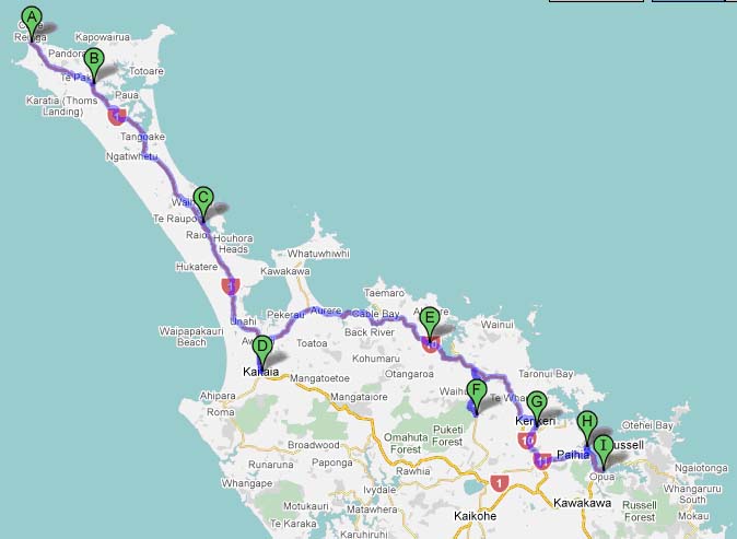
Ivan Brown, our coach captain, welcomed 14 new people to our tour group, as he departed Auckland in the morning after Christmas on the 325-km trip north to Kaitaia, a town of 5,200 people at the base of the Aupouri Peninsula, which is a tomboloƒÆ’‚¢ƒ¢-¡‚¬ƒ¢¢”š¬‚a deposition landform in which an island is attached to the mainland by a narrow piece of land such as a spit or bar.
On the way to Far North
Our first stop on the way north was the Dome Valley Roadhouse, just south of Wellsford, about 75 km north of our starting point. Our lunch stop was at Whangarei (population 51,400), located on the Hatea River, almost 160 km north of Auckland. It is the northernmost city in New Zealand and the regional capital of Northland Region. Here we visited the Bounty Museum [photo] and ate lunch at the Grand Establishment Hotel.
At Kaikohe, 85 km further to the northwest, we visited the now defunct High Lake Dairy Farm, where the farmhands gave us a tour of the farm and a demonstration of milking.
We reached Kaitaia, the last major settlement on the main road north to the capes and bays on the peninsula, after driving 81km further northwest. ƒÆ’-¡ƒ”š‚ We checked in at Kaitaia Hotel.
After dinner, Yoke-Sim and I accompanied our son Junius to the childrenƒÆ’‚¢ƒ¢-¡‚¬ƒ¢-¾‚¢s playground in the park to the east of the hotel. He derived immense enjoyment climbing up and down the train engine and the tractor placed in the park.
Exploring the Tombolo
Sunday (27 Dec.) morning, we had to get onto a new bus that could withstand the unsealed terrain and the sand dunes of the Aupouri Peninsula for our adventure trip to Cape Reinga (ƒÆ’‚¢ƒ¢-¡‚¬ƒ…-Place of LeapingƒÆ’‚¢ƒ¢-¡‚¬ƒ”š‚), 111 km north of Kaitaia.
Five km west of the town lies Ahipara/Shipwreck Bay, from where the so-called Ninety Mile Beach (actually an 88-km long beach) stretches all the way northwest to Scott Point, five km south of Cape Maria van Diemen. In 1932, Ninety Mile Beach was used as the runway for some of the earliest airmail services between Australia and New Zealand. Our return trip from the cape took this long beach route so popular with surfers and water boarders.
However, our forward journey to the northernmost cape in New Zealand followed the old faithful Highway 1, which is sealed except for the last 20 km. It starts in Kaitaia as North Road and ends as Cape Reinga Road.
We took the North Road to Awanui, then turned northwest to cross over to the tombola through the narrow isthmus between Waipapakauri and WaihararaƒÆ’‚¢ƒ¢-¡‚¬ƒ¢¢”š¬‚a 10 km stretch.
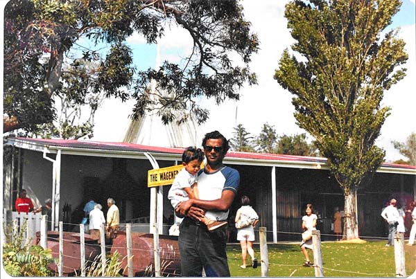
Then, 44 km north of Kaitaia, we stopped at the Wagener Museum [photo] overlooking the Houhora Harbor and Mount Camel. The museum had an interesting collection of old musical instruments, clocks, washing machines, insects, shells, etc.ƒÆ’-¡ƒ”š‚
Back on the main drag, we had a look at Houhora Hotel, the northernmost hotel in New Zealand. About 25 km further northwest, we paused on a hilltop to look at the Parengarenga Harbor, the assembling place of thousands of bar-tailed godwits in late February to early March for their 12,000-km journey to Siberia.
We stopped for a smorgasbord lunch at the Waitiki Landing, the northernmost restaurant in New Zealand, about 20 km southeast of the cape. Then, past Te Paki station, we reached Cape Reinga [photo], where all of us took a walk down to the lighthouse.
On the return journey, we backtracked Highway 1 to Te Paki and drove south on the unpaved Te Paki Stream Road to the sand dunes of the Ninety Mile Beach, which serves as the alternative to Highway 1 during floods and landslides.
Many stop for boogie boarding or tobogganing down the huge sand dunes flanking the Te Paki Stream. Because none in our tour group was enticed by sand dunes, our special sand-resistant vehicle headed southeast for the return trip.
We stopped at The Bluff [photo] briefly, then proceeded past Hukatere to Waipapakauri Beach, where we turned inland on West Coast Road to visit the Sweetwater Nursery of radiata pines, near Lake Ngatu.
We returned to Kaitaia about 4.30 p.m. The dinner was very good. Junius had a marvelous time dancing to music. But all was not well. I experienced a sore throat and other symptoms of a detested cold.
In the Bay of Islands
Monday (28 Dec.) morning, we left Kaitaia for Russell on the Bay of Islands via scenic Highway 10. Past the Kaingaroa Valley, Lake Chia, Charles Bay, Coopers Beach and Mangonui Harbor, we crossed the Paewhenua Island to reach the Kahoe Township, our first stop of the day, 57 km east of Kaitaia.
Driving another 31 km southeast, we reached the Manginangina Scenic Reserve on the eastern edge of Puketi Forest. Here we tried to hobnob with the giant kauri trees, some of which are more than 1,000 years old. But the giants didnƒÆ’‚¢ƒ¢-¡‚¬ƒ¢-¾‚¢t pay attention to our brief exercise of self-propulsion.
After backtracking to Highway 10, we stopped to eat lunch at the Tea Rooms in Kerikeri (population 6,000), also called the Cradle of the Nation because it is the site of the first permanent mission station (1822) in New Zealand, and it has some of the most historic buildings in the country, including the old stone store (1823).
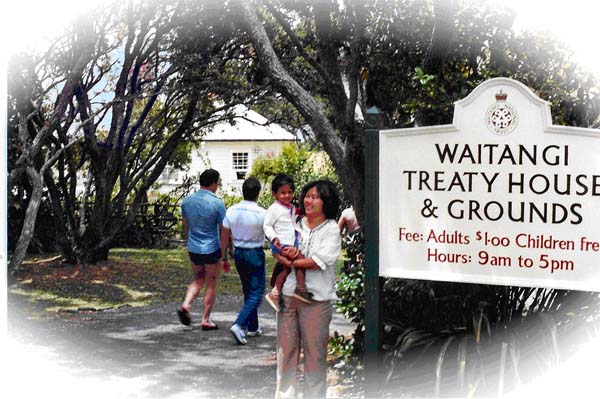
The purpose of our visit to the Bay of Islands was to get acquainted with the historic towns associated with the emergence of New Zealand as a colony of the British Crown. Therefore, we next visited the township of Waitangi (ƒÆ’‚¢ƒ¢-¡‚¬ƒ…-Weeping WatersƒÆ’‚¢ƒ¢-¡‚¬ƒ”š‚) [photo], the place where the Crown representatives and the Maori chiefs of the Far North signed the Treaty of Waitangi on 6 Feb. 1840. The English and the Maori versions of the treaty were later found to be not the same. The treaty established a British governor in New Zealand, recognized the land and property rights of the Maori, and gave Maori the rights of British subjects. However, the treaty was ineffective until 1975, when the Waitangi Tribunal was set up as a permanent body to adjudicate on complaints.
Waitangi was also the place where the Declaration of Independence was signed on 28 Oct. 1835, which was effectively nullified by the treaty that established New Zealand as a Crown colony. The government built the Maori Meeting House (Te Whare Runanga) next to the Treaty House (the house of the British representative James Busby) to celebrate New ZealandƒÆ’‚¢ƒ¢-¡‚¬ƒ¢-¾‚¢s centenary celebrations in 1940.
Located to the south of Waitangi, Paihia (population 1,770) is the main town in the Bay of Islands. South of Paihia, we (bus included) took the ferry at Opua to cross over toƒÆ’-¡ƒ”š‚ ƒÆ’-¡ƒ”š‚ ƒÆ’-¡ƒ”š‚ ƒÆ’-¡ƒ”š‚ ƒÆ’-¡ƒ”š‚ ƒÆ’-¡ƒ”š‚ ƒÆ’-¡ƒ”š‚ ƒÆ’-¡ƒ”š‚ ƒÆ’-¡ƒ”š‚ ƒÆ’-¡ƒ”š‚ ƒÆ’-¡ƒ”š‚ ƒÆ’-¡ƒ”š‚ ƒÆ’-¡ƒ”š‚ ƒÆ’-¡ƒ”š‚ ƒÆ’-¡ƒ”š‚ ƒÆ’-¡ƒ”š‚ ƒÆ’-¡ƒ”š‚ ƒÆ’-¡ƒ”š‚ ƒÆ’-¡ƒ”š‚ ƒÆ’-¡ƒ”š‚ ƒÆ’-¡ƒ”š‚ ƒÆ’-¡ƒ”š‚ ƒÆ’-¡ƒ”š‚ ƒÆ’-¡ƒ”š‚ ƒÆ’-¡ƒ”š‚ ƒÆ’-¡ƒ”š‚ ƒÆ’-¡ƒ”š‚ ƒÆ’-¡ƒ”š‚ ƒÆ’-¡ƒ”š‚ ƒÆ’-¡ƒ”š‚ ƒÆ’-¡ƒ”š‚ ƒÆ’-¡ƒ”š‚ ƒÆ’-¡ƒ”š‚ ƒÆ’-¡ƒ”š‚ ƒÆ’-¡ƒ”š‚ ƒÆ’-¡ƒ”š‚ ƒÆ’-¡ƒ”š‚ ƒÆ’-¡ƒ”š‚ ƒÆ’-¡ƒ”š‚ ƒÆ’-¡ƒ”š‚ ƒÆ’-¡ƒ”š‚ ƒÆ’-¡ƒ”š‚ ƒÆ’-¡ƒ”š‚ ƒÆ’-¡ƒ”š‚ ƒÆ’-¡ƒ”š‚ ƒÆ’-¡ƒ”š‚ ƒÆ’-¡ƒ”š‚ ƒÆ’-¡ƒ”š‚ ƒÆ’-¡ƒ”š‚ ƒÆ’-¡ƒ”š‚ ƒÆ’-¡ƒ”š‚ ƒÆ’-¡ƒ”š‚ ƒÆ’-¡ƒ”š‚ ƒÆ’-¡ƒ”š‚ ƒÆ’-¡ƒ”š‚ ƒÆ’-¡ƒ”š‚ ƒÆ’-¡ƒ”š‚ Okiato (old Russell, New ZealandƒÆ’‚¢ƒ¢-¡‚¬ƒ¢-¾‚¢s first capital) on the eastern side of the Bay of Islands. Nine km north is new Russell (earlier called Kororareka), the first permanent European settlement in New Zealand, dating from the early 1800s. Old Russell was New ZealandƒÆ’‚¢ƒ¢-¡‚¬ƒ¢-¾‚¢s first capital before the capital shifted to Auckland and eventually to Wellington.
Our ferry trip saved us more than 100 km of driving around the Russell Forest to reach Russell (population 816), where we checked in at the Duke of Marlborough Hotel on The Strand. Before dinner, I strolled the streets of the town with my family and purchased a copy of The (Whangarei) Northern Advocate for later reading.
The next morning, we got on board the boat Waikare II for a cruise on the Bay of Islands. This three-hour outing gave us a closer look at the islands lying to the northeast of Russell: Motorarokia (Robertson), Moturua (MitaƒÆ’‚¢ƒ¢-¡‚¬ƒ¢-¾‚¢s), Motukiete, Okahu, Waewaetoria and UrupukapukaƒÆ’‚¢ƒ¢-¡‚¬ƒ¢¢”š¬‚not a bunch of easy-to-remember names. We also saw the two neighboring bays, Pakura and Waipiro, lying to the south of the chain of islands, which I decline to spell out again! Since, it took me several attempts to spell out each of these names with accuracy, I wondered why every bay, tombola, fjord and loch in the world should bear a name.
Back in Russell, we ate lunch at the now defunct Traders Inn. In the afternoon, Junius, Yoke-Sim and I had a very enjoyable bushwalk to the top of Flagstaff Hill [photo], which the British used to fly the Union Jack following the Treaty of Waitangi. The Maori resented the flag as a sign of slavery. Shifting the capital to Auckland in 1841 angered the Maori so much that Hone Heke, a local Maori chief, had chopped the flagstaff on three occasions.
As my sore throat and other symptoms of a cold disappeared from my system, I fell more at ease to end our long Tiki Tour, which began in Christchurch on 12 Dec. 1981.
Au Revoir Auckland
Wednesday (30 Dec. 1981): Ivan Brown, who had been our inestimable guide and ƒÆ’‚¢ƒ¢-¡‚¬ƒ…-steerologistƒÆ’‚¢ƒ¢-¡‚¬ƒ”š‚ in North Island, took us back to Auckland leaving Russell about 8.30 a.m. This time we took the ferry from OkiatoƒÆ’-¡ƒ”š‚ (old Russell) to Opua, from where Auckland lies 224 km to the south. Heading southwest on Highway 11, we merged into Highway 1 at Kawakawa.
Our first stop was at Whangarei Falls 62 km from Opua. Then we drove to the top of the Parahaki Nature Reserve to get a good look at Whangarei, where we stopped in the forward journey as well. Our lunch stop was Dome Valley Roadhouse. We reached Auckland about 3 p.m.
Before our Tiki Tour grouped dispersed, Brown took us on a small-scale sightseeing excursion of the Big City, something he failed to do on our first stop on Christmas Day. Perhaps he intended it as his act of farewell. He drove us along Tamaki Drive to Bastion Point to see the memorial to M. J. Savage (1872-1940), who was the first Labor prime minister of New Zealand during the last five years of his life. Bastion Point, which overlooks the Waitemata Harbor, is a coastal stretch of land in Orakei associated with Maori protests of 1977. Then, he took us to see the magnificent homes on Paritai Drive in the same eastern suburb. The property values in the vicinity ranged from $3 million to $12 million. Finally, he took us through the Auckland Domain to the top of Mount Eden Reserve (196 meters), almost 10 km to the southwest, from where ƒÆ’‚¢ƒ¢-¡‚¬ƒ…-one could see the city all round.ƒÆ’‚¢ƒ¢-¡‚¬ƒ”š‚
Our plan was to stay two more nights at the Royal International in Auckland before returning to Australia Friday (1 Jan. 1982) evening.ƒÆ’-¡ƒ”š‚
We spent Thursday morning shopping in downtown Auckland.ƒÆ’-¡ƒ”š‚ In the afternoon, we watched Junius chasing pigeons at the Aotea Square [photo] created in 1979 to accommodate public events, including fairs, protest rallies, music festivals, rock concerts and the annual seeing-in of the New Year. We spent the rest of the afternoon at the Zoological Park in Western Springs ($3 per head).
This evening, Yoke-Sim and I decided to celebrate the end of our Tiki Tour as well as the old year, with a grand Indian dinner at the Maharajah Restaurant at the top of Khyber Pass. Junius appeared to relish Indian cuisine. The cost of the meal ($25) was insignificant compared to the enjoyment we derived.
We celebrated the New Year with a trip to the Rangitoto Island the next morning [photo]. There, we joined a two-hour adventure tour of the island, an active volcano only 200 years ago, on the Magic Bus. We were back at the Waitemata Harbor on the mainland at 2.30 p.m. Later, a limousine took us from the hotel to the Auckland Airport well in time for our Qantas flight to Brisbane at 7.30 p.m.
ƒÆ’-¡ƒ”š‚ Next: Weekend Excursions in California
ƒÆ’-¡ƒ”š‚ (The writer is a professor of mass communications emeritus, Minnesota State University Moorhead.)ƒÆ’-¡ƒ”š‚
Figure 1: Our exploration tour route of Aupouri Peninsula (Tombola) and the Bay of Islands in the Far North of New Zealand.ƒÆ’-¡ƒ”š‚ A=Cape Reinga, B=Waitiki Landing, C=Hauhora Harbor, D=Kaitaia, E=Kahoe, F= Manginangina Scenic Reserve, G=Kerikeri, H=Waitangi, I=Opua (from where we took a ferry ride to Okiato [old Russell] and drove nine km north to Russell [old Kororareka]).
Picture 1: Yoke-Sim, carrying Junius, stands at the entrance to the Waitangi Treaty House and Grounds (28 Dec. 1981)
Picture 2: The writer, with Junius in his arms, stands in front of the Wagener Museum at Houhora Harbor in the Aupouri Peninsula (27 Dec.ƒÆ’-¡ƒ”š‚ 1981).


March 14th, 2010 at 6:57 pm
I wonder how Mr. Guneratna’s travels are linked to the national interests of Sri Lanka as my assertion was that Lanka web is a site that provides insight into Sri Lankan issues. Can someone explain if I have missed a point please?
March 16th, 2010 at 8:03 pm
Lankaweb describes itself as “the Sri Lanka’s first Social Media website in it’s true sense. It’s a fusion of sociology and technology, transforming monologues (one to many) into dialogues (many to many) and is the democratization of information, transforming people from content readers into publishers.”
Although it claims to be “The Independent Interactive Voice of Sri Lanka on the Internet for over 15 years.” it does not anywhere assert that it is limited to the discussion of Sri Lankan issues only.
Lankaweb’s readership includes thousands of Sri Lankan expatriates who have permanently settled down overseas. Lankaweb contributors are predominantly from this group. Their activities and interests are, therefore, of great interest to Lankaweb. Moreover, one cannot compartmentalize issues into clear-cut Sri Lanakan issues or Indian issues because all issues have international implications.
Buddhist philosophy asserts that everything and everyone in the world/universe is interconnected. Nothing exists in isolation. All issues arise out of interaction of everything in the environment, which goes well beyond national boundaries.
The objectives of “The Travels of a Journalst” are:
1. To expand the geographical and cultural horizons of its readers.
2. To promote travel as a recreational activity among its readers
3. To present a series of actual experiences in elegant literary styyle that others may emulate
4. To encourage readers to get into travel writing as a hobby
5. To make it abundantly clear that travel writing is not the preserve of the Western elite.
have international implications
March 18th, 2010 at 2:36 am
Fascinating writing by, Shelton (now senior citizen?). I cannot wait for the next episode. Thank you Lankaweb for giving us such fatasitic reading (I wonder why Shelton gave the son the bizare name, Junius – is this to give respect to the old fox, Junius Jayawardane? If yes, oh my god.