The Travels of a Journalistâ€â€ÂÂ39,EXPLORING ‘RIM OF THE WORLD’ IN SAN BERNARDINO MOUNTAINS
Posted on July 6th, 2010
By Shelton A. Gunaratne ƒÆ’-¡ƒ”š‚© 2010
I started my focus on California/West Coast travel adventures three months agoƒÆ’‚¢ƒ¢-¡‚¬ƒ¢¢”š¬‚from Travels-18 (ƒÆ’‚¢ƒ¢-¡‚¬ƒ…-California adventures: Mingling with giant sequoiasƒÆ’‚¢ƒ¢-¡‚¬ƒ”š‚) onwards. In the travelogues that followed, I attempted to dramatize the vast experience I gathered as an inveterate traveler in 1983, the year I spent in California as an exchange instructor at Fullerton College.
In 1966-67, my first year of worldwide travel experience as a fellow of the World Press Institute, I was more a participant than a travel planner. In 1983, I was the master of my own (and my familyƒÆ’‚¢ƒ¢-¡‚¬ƒ¢-¾‚¢s) destiny.ƒÆ’-¡ƒ”š‚ Writing about these travels in 2009-10 presented another challengeƒÆ’‚¢ƒ¢-¡‚¬ƒ¢¢”š¬‚the need to update what I had noted down in my diaries. Willy-nilly, I had to do the research and check the accuracy of spelling of names, distances, directions and developments. I relied heavily on the Wikipedia and the Google maps. Time available to me after my retirement enabled me to develop 23 composite or separate stories related to my Fullerton Year.
Travels-40 will conclude my series on California. I began the stories on the five-county Greater Los Angeles with Travels-28 (ƒÆ’‚¢ƒ¢-¡‚¬ƒ…-Exploring Southland: Making the best out of Greater L.A.ƒÆ’‚¢ƒ¢-¡‚¬ƒ”š‚). However, I failed to focus on San Bernardino County, except for mentioning our stopovers in two places on its western border: Sleepy Hollow (in Travels-28) and Orange (in Travels-31, ƒÆ’‚¢ƒ¢-¡‚¬ƒ…-Greater L.A. offers many offbeat attractions en route to camping in San Gabriel WildernessƒÆ’‚¢ƒ¢-¡‚¬ƒ”š‚).ƒÆ’-¡ƒ”š‚
ƒÆ’-¡ƒ”š‚ Focus on San Bernardino
ƒÆ’-¡ƒ”š‚ Yoke-Sim and Junius left for Australia on 1 Jan. 1984 leaving me and my mother to fend for ourselves in Fullerton for the rest of January. This allowed us the rare opportunity to indulge in nostalgic conversation about my childhood days in Pathegama, my birthplace in southern Sri Lanka.
On the day I turned 44 (Sunday 22 Jan. 1984), exactly a week before the end of my Fullerton exchange, mother treated me to a traditional village breakfast of kiri bath (ƒÆ’‚¢ƒ¢-¡‚¬ƒ…-milk-riceƒÆ’‚¢ƒ¢-¡‚¬ƒ”š‚). To celebrate the occasion, I took my mother, then 70, on a daylong 210-mile roundtrip excursion to San Bernardino Mountains.
(Background: San Bernardino County, which is part of Greater Los Angeles, is home to more than 2.1 million people spread out in an area of 20,105 square miles. In geographical size, it is the largest county in the ƒÆ’‚¢ƒ¢-¡‚¬ƒ…-Lower 48ƒÆ’‚¢ƒ¢-¡‚¬ƒ”š‚ states of the U.S. It has 25 incorporated communities, of which the largest is the 82-square-mile city of San Bernardino (pop. 205,000), the county seat. The next five largest cities are Fontana (pop. 180,700), Rancho Cucamonga (pop. 174,300), Ontario (pop. 172,700), Victorville (pop. 102,600) and RialtoƒÆ’-¡ƒ”š‚ (pop. 100,000).ƒÆ’-¡ƒ”š‚ All the big cities lie closer to the border of Los Angeles County again indicating the population exodus from L.A. metropolitan area to San Bernardino and Riverside counties, the so-called Inland Empire, for cheaper housing.
The city of San Bernardino lies about 50 miles northeast of Fullerton via Corona and Riverside. It is the home of the University of California San Bernardino. Its various attractions include the Fox Performing Arts Center, the California Theatre, the Robert V. Fullerton Museum of Art, Route 66-McDonald’s Museum, the Santa Fe Rail Road Museum and the Arrowhead Springs Resort and Hotel.)
When we arrived in San Bernardino on 22 Jan. (Sunday), we used the city only as a gateway to the eponymous mountains. My mother had no cultural interest in visiting any of the listed attractions. Therefore, immediately after arrival in the city, I headed north on
Waterman Avenue, which turns into the Rim of the World Highway (SR 18) as it enters the mountains in the San Bernardino National Forest. Crestline (pop. 10,300) lies around Lake Gregory at the north end of the initial 16-mile stretch of the Rim of the World. Then, the highway takes a sharp turn east to zigzag its way to other points of interest.
Just three months earlier, on another Sunday (30 Oct. 1983), Junius, Yoke-Sim and I had been within 20-30 miles northwest of Crestline as we crossed the national forest from LA County to SB County at Wrightwood on our drive through Angeles Crest Highway (SR 2), which terminates at its junction with SR 138.ƒÆ’-¡ƒ”š‚ Heading southeast from the junction, SR 138 links Angeles Crest Highway (SR 2) with Rim of the World Highway (SR 18) at Crestline. So, it seemed to me, that mother and I were continuing to explore the crest of the same chain of mountains.
No visitor to San Bernardino Valley can miss the immense Arrowhead geological landmark on the side of the San Bernardino Mountains stretching some 60 miles in an east-west direction. I have it on authority that the face of the arrowhead consists of light quartz, supporting a growth of short white sage; and that this lighter vegetation shows in sharp contrast to the surrounding chaparral and greasewood. The native Indians in the San Bernardino Valley considered the vicinity holy ground because they believed that the arrowhead pointed the way to the hot mineral springs below, with healing qualities.
At Rimforest, we drove two miles northwest on Bear Springs Road to reach the lookout to view Strawberry Peak (elevation: 6,155 feet /1,876.04 m). Then, back on SR 18, we came to Crest Park, where we turned north on SR 173 and drove less than two miles to reach Lake Arrowhead (pop 9,000), named after the renowned geographical landmark. Located 23 miles north and northeast of San Bernardino, the unincorporated community of Lake Arrowhead depends almost entirely on tourism. About 4 million people visited the area in 2009. The adjacent 780-acre Lake Arrowhead Reservoir is an artificial lake.
Mother and I walked around the shopping village and refreshed ourselves with junk food from the MacDonaldƒÆ’‚¢ƒ¢-¡‚¬ƒ¢-¾‚¢s.
Next, back on SR 18, we visited the now-defunct SantaƒÆ’‚¢ƒ¢-¡‚¬ƒ¢-¾‚¢s Village, a popular theme park from 1959-1998, near Skyforest. Another attraction was the nearby Heaps Peak Arboretum. Communities in the vicinity include Cedar Glen, Blue Jay, Rimforest, Deer Lodge Park and Agua Fria.ƒÆ’-¡ƒ”š‚ We drove past Running Springs (pop. 5,200), the junction where SR 330 provides a short cut to return to San Bernardino via Highland.
Heading further east on SR 18, we took Keller Peak Road to visit the National ChildrenƒÆ’‚¢ƒ¢-¡‚¬ƒ¢-¾‚¢s Forest. The drive involved a steep climb from 6,000 ft. to 7,882 ft. along a smooth, paved, two-lane road to the top of Keller Peak. The view from the peak was breathtaking. Created in the wake of the 1970 Bear Fire, the National Children’s ForestƒÆ’‚¢ƒ¢-¡‚¬ƒ¢¢”š¬‚3,400 acres of forest nestled between Rim of the World Highway and Keller Peak RoadƒÆ’‚¢ƒ¢-¡‚¬ƒ¢¢”š¬‚is a unique forest-fire study area dedicated to thousands of children nationwide who have helped reforest the country’s burned timber. It was here that my mother touched and tasted snow for the first time in her life.
ƒÆ’-¡ƒ”š‚ Then, past the scenic Lake View Point (elev. 7,207 ft.), we headed toward Big Bear Lake (pop. 5,500), the largest recreation lake in Southern California. SR 18 continues along the seven-mile length of the South Shore of the reservoir while its North Shore (SR 38) begins at the Dam Junction of SR 18. We took the North Shore route, which travels east past the historic location of Gray’s Landing, a famous 1920s fishing camp. It turns north around Grout Bay and travels through the small unincorporated town of Fawnskin. The road meanders across North Shore through Forestry lands, past the Big Bear Solar Observatory, Big Bear Discovery Center, the Serrano Campground (USFS) and Stanfield Cutoff, and continues into Big Bear City.
After stopping at the solar observatory, we drove a few miles north on a dirt road to Holcomb Valley, where we saw the sites of WilkerƒÆ’‚¢ƒ¢-¡‚¬ƒ¢-¾‚¢s Grave, Two Gun BillƒÆ’‚¢ƒ¢-¡‚¬ƒ¢-¾‚¢s Saloon and HangmanƒÆ’‚¢ƒ¢-¡‚¬ƒ¢-¾‚¢s Tree, all associated with CaliforniaƒÆ’‚¢ƒ¢-¡‚¬ƒ¢-¾‚¢s Gold Rush days. Back on SR 38, we drove to Big Bear City, where SR 18 crosses over to the north and goes northeast for a short distance before taking a northwestern direction all the way to Victorville; and SR 38 crosses over to the south and goes southeast for quite a distance before taking a south-westward direction all the way to Redlands.
We drove on SR 38 for our return journey. Our next stop was Barton Flats, which is directly south of Big Bear Lake although we had to drive 21 miles to get there. The purpose of the stop was for me to try out walking through the Ponderosa Nature Trail and the Whispering Pines Trail.ƒÆ’-¡ƒ”š‚
Meanwhile, my mother was getting impatient as it was getting dark. She had little interest in the activities I was enjoying. Darkness set in as we reached Forest Falls, 16 miles further southwest. To make matters worse, our vehicle skidded on an icy patch of the highway. Although two Good Samaritans came to our rescue and helped me straighten up the car for safe driving, the incident aggravated my motherƒÆ’‚¢ƒ¢-¡‚¬ƒ¢-¾‚¢s anxiety to get back home.
I had no option but to return to Fullerton, a distance of 70 miles from Forrest Falls via Redlands.
We reached our Fullerton condo before 7.30 p.m. Despite the vehicle mishap, I enjoyed my 44th birthday exploring another scenic spot of the world. Moreover, on this trip, I saw the joy of my motherƒÆ’‚¢ƒ¢-¡‚¬ƒ¢¢”š¬‚the erstwhile Punchi Hamine from the village of Pathegama in the Deep South of Sri LankaƒÆ’‚¢ƒ¢-¡‚¬ƒ¢¢”š¬‚as she touched and tasted some snow for the first time in her life!
ƒÆ’-¡ƒ”š‚ Next: Concluding article on California
(The writer is professor of mass communications emeritus, Minnesota State University Moorhead.)
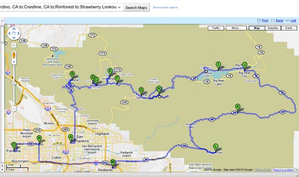
ƒÆ’-¡ƒ”š‚  Figure 1: Rim of the World Highway from A=San Bernardino to J=Big Bear City. Other codes: B=Crestline; C=Rainforest; D=Strawberry Lookout; E=Lake Arrowhead; F=Skyforest (SantaƒÆ’‚¢ƒ¢-¡‚¬ƒ¢-¾‚¢s Village); G=Running Springs; H=National ChildrenƒÆ’‚¢ƒ¢-¡‚¬ƒ¢-¾‚¢s Forest; I=North Shore/Big Bear Lake; J=Big Bear City; K=Barton Flats; L=Forest Falls; M=Redlands; N=Rialto; O=Fontana. Distance from A-O: 142 miles.
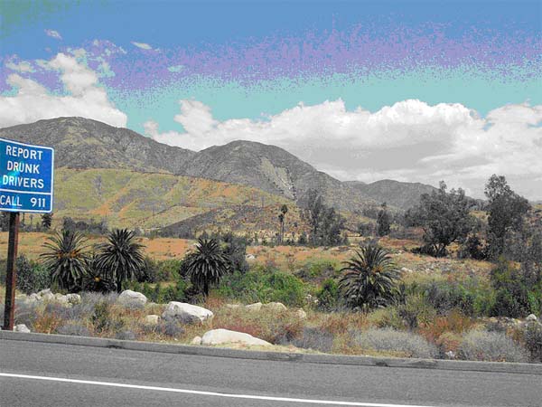
ƒÆ’-¡ƒ”š‚ Picture 1: Driving up to the mountain community of Crestline surrounding Lake Gregory, one can see the natural geographical landmark resembling an arrowhead on the side of a mountain peak. Legend has it that this large arrowhead guided the Indians to the springs. The landmark void of natural vegetation has been visible for hundreds of years.
Source: Wikimedia Commons
ƒÆ’-¡ƒ”š‚  ƒÆ’-¡ƒ”š‚ Picture 2: The author and his mother at the Japan Center in San Francisco–a month before their visit to the San Bernardino Mountains.
ƒÆ’-¡ƒ”š‚
ƒÆ’-¡ƒ”š‚
