The Travels of a Journalistâ€â€ÂÂ62-Adventures on Canadian Rockies: A drama between man and nature
Posted on March 17th, 2011
By Shelton A. Gunaratne ƒÆ’-¡ƒ”š‚©2011 Professor of mass communications emeritus@ Minnesota State University Moorhead
ƒÆ’-¡ƒ”š‚ British Columbia covers a land area of 925,186 sq. km with a population density of 4.8 people per square kilometer. One-half the BC population lived in the Greater Vancouver metropolitan area.ƒÆ’-¡ƒ”š‚ For me, the vast patches of uninhabited land I saw in my foray into Caribou Country in 1967 were utterly depressing (Figure 1).ƒÆ’-¡ƒ”š‚ ƒÆ’-¡ƒ”š‚
The population density of the adjoining provinces of Alberta (5.8), Saskatchewan (1.7) and Manitoba (2.2) along Trans-Canada (Highway 1) was even thinner than that of BC except for the slightly higher figure for Alberta.ƒÆ’-¡ƒ”š‚ Thus, driving across Canada from Victoria, BC, to Winnipeg, Manitoba, a distance of 2,457 km, with vast patches of sparsely inhabited barren land straddling metropolitan conurbations would be as ƒÆ’‚¢ƒ¢-¡‚¬ƒ…-interestingƒÆ’‚¢ƒ¢-¡‚¬ƒ”š‚ as crossing the Nullarbor or the ƒÆ’‚¢ƒ¢-¡‚¬ƒ…-Big SkyƒÆ’‚¢ƒ¢-¡‚¬ƒ”š‚ country unless one were an authentic misanthrope.
After leaving Burnaby Thursday (31 Aug. 1989), weƒÆ’‚¢ƒ¢-¡‚¬ƒ¢¢”š¬‚Carmel, 5; Junius, 9; Yoke-Sim and IƒÆ’‚¢ƒ¢-¡‚¬ƒ¢¢”š¬‚drove 64 km southeast on Trans-Canada 1 to Abbotsford, where the highway turns northeast to reach Hope (pop. 6,185), located on the confluence of Fraser and Coquihalla rivers, about 84 km away.
ƒÆ’-¡ƒ”š‚ 
Figure 1: From Vancouver to Prince Rupert via Prince George — My solo tour of British Columbia in 1967. (Distance covered=1,519 km)
A=Vancouver; B=Abbotsford; C=Hope/Exit to Coquihalla toll road; D=Cache Creek/ Junction of Highway 97 and Trans-Canada (Highway 1); E=Williams Lake; F=Quesnel; G=Prince George; H=Burns Lake; I=Cedarvale/Minskinish; J=Prince Rupert.
About 7 km east of Hope, at an uninhabited location known as “Othello,” we left Trans-Canada to get on what was then BCƒÆ’‚¢ƒ¢-¡‚¬ƒ¢-¾‚¢s only toll road, Highway 5 (also known as the Coquihalla Highway or ƒÆ’‚¢ƒ¢-¡‚¬ƒ…-the CokeƒÆ’‚¢ƒ¢-¡‚¬ƒ”š‚). We thought it was worth the $10 toll to drive on the 186 km- toll road (a freeway since 2008) rather than sticking on to Trans-Canada 1 all the way to Cache Creek and turn east to Kamloops, Besides, I had already been to Cache Creek and beyond on my 1967 journey on the Caribou Trail. The toll was well worth the extra distance of roughly 75 km we saved by taking ƒÆ’‚¢ƒ¢-¡‚¬ƒ…-the Coke.ƒÆ’‚¢ƒ¢-¡‚¬ƒ”š‚
ƒÆ’-¡ƒ”š‚ 
Figure 2: Our 1989 Tour Route from Hope to Yard Creek Provincial Park (365 km)
A=Hope/Othello; B=Merritt; C=Kamloops; D=Chase; E=Sorrento, F=SalmonƒÆ’‚¢ƒ¢-¡‚¬ƒ¢-¾‚¢s Arm; G=Sicamous; H=Yard Creek Provincial Park.
Torrential Rain
Highway 5 generally follows the Coquihalla River for about 60ƒÆ’-¡ƒ”š‚ km near Hope. Some 35ƒÆ’-¡ƒ”š‚ km north of Othello, after passing through five interchanges, Highway 5 reaches the Great BearƒÆ’-¡ƒ”š‚ snow shed, a landmark on the route. Another 13ƒÆ’-¡ƒ”š‚ km north of the snow shed, after passing through another interchange and the 1,244-meter Coquihalla Pass, Highway 5 reaches (the former) tollbooth. It goes through three more interchanges and one mountain pass, the 1,444-meter Clapperton Creek Summit, in its remaining 72ƒÆ’-¡ƒ”š‚ km between Merritt (pop. 6,998) and its end at a junction with Highways 1 and 97 within the Afton area of Kamloops (pop. 92,882), the largest community in theƒÆ’-¡ƒ”š‚ Thompson-Nicola Regional DistrictƒÆ’-¡ƒ”š‚ and the location of the regional district’s offices.
ƒÆ’-¡ƒ”š‚ 
A landmark feature of the southern leg of BC Highway 5 is the Great Bear Snow Shed (September 2007)
Source: Wikimedia Commons. Photo by Dimbeko]
ƒÆ’-¡ƒ”š‚
The mountainous terrain we passed through was prone to outbursts of torrential rain. Yoke-Sim drove our car on ƒÆ’‚¢ƒ¢-¡‚¬ƒ…-the CokeƒÆ’‚¢ƒ¢-¡‚¬ƒ”š‚ from Merritt to Kamloops when thunder and lightning warned us of an impending rainstorm. In Kamloops, we stopped at the Aberdeen shopping mall to buy some knick-knacks; and at Safeway to purchase the food we needed for dinner. ƒÆ’-¡ƒ”š‚ Currently, Aberdeen Mall is home to more than 100 stores and services including restaurants like East Side MarioƒÆ’‚¢ƒ¢-¡‚¬ƒ¢-¾‚¢s and New York Fries (Wikipedia).
Despite the threat of torrential rain, we decided to drive as far as possible to come close to the BC-Alberta borderlineƒÆ’‚¢ƒ¢-¡‚¬ƒ¢¢”š¬‚361 km further to the east.
The threat materialized as I drove my faithful Toyota Camry wagon toward the village of Chase (pop. 2,409), located on the south shore of Little Shuswap Lake. Trans-Canada 1 snakes around Mount Chase and Squilax Mountain to reach the unincorporated community of Sorrento on the southeastern edge of Shuswap Lake. Then, the road takes a sharp southward turn to reach the current city of Salmon Arm (pop. 16,205) on the shores of Shuswap Lake where the Salmon River empties into the Salmon Arm reach of the lake. The 1998 wildfire destroyed 5,000 hectares of forestland south of Salmon Arm, including 20 homes and 15 barns.
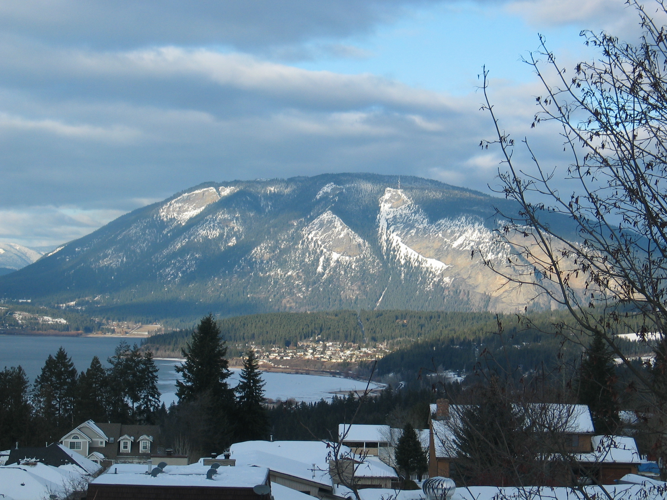

Bastion Mountain as seen from Salmon Arm of Shuswap Lake (December 2010)
Source: Wikimedia Commons. Photo by Metallurgist]
ƒÆ’-¡ƒ”š‚
Although my description of the mountainous terrain we crossed might conjure up images of scenic splendor, the conditions of driving through the Canadian Rockies imposed on us much fear and tension. The windshield wipers of our vehicle could not at times cope with the velocity of rainwater lashing on our vehicle. Road visibility diminished to near zero at times so much so that we realized the folly of taking up this unwinnable fight with nature by ignoring the ample warning signs of the impending rainstorm. Now, nature was punishing us with its combined force s of rain, wind, thunder and lightning. Gripped by tension, Carmel and Junius hugged on to their pillows in the back seat of the car to distract their attention from the wrath of nature. We remembered the similar but less aggravating plight we faced when we drove through a thick fog Wednesday morning on the Mount Seymour Parkway.
The anger of the cosmic forces that control the skies appeared to have subsided by the time Trans-Canada Highway 1 took us 31 km northeast along the southern shore of Salmon Arm all the way to Sicamous (pop. 3,132), located opposite the Bastion Bay. This area was the habitat of the Secwepemc or Shuswaps tribe of Native Americans before the influx of white settlers, particularly after the Big Bend Gold Rush of 1864.
It was 10.30 p.m. when we reached our campground in the Yard Creek Provincial Park in Malakwa, 16 km east of Sicamous. The BC-Alberta boundary line was another 208 km to the northeast.
Yard Creek provided the rest we needed after driving a distance of 554 km during the day.
(To be continued)
ƒÆ’-¡ƒ”š‚