The Travels of a Journalistâ€â€ÂÂ63 – BC cop issues royal order To pay $75 fine at border
Posted on March 20th, 2011
By Shelton A. Gunaratne ƒÆ’-¡ƒ”š‚©2011 Professor of mass communications emeritus@ Minnesota State University Moorhead
WeƒÆ’‚¢ƒ¢-¡‚¬ƒ¢¢”š¬‚Carmel, 5; Junius, 9; Yoke-Sim and IƒÆ’‚¢ƒ¢-¡‚¬ƒ¢¢”š¬‚got up Friday (1 Sept. 1989) morning watching the American dippers and a variety of little bird species dive into the icy waters of Yard Creek and “fly” along under the water looking for their ƒÆ’‚¢ƒ¢-¡‚¬ƒ…-yummyƒÆ’‚¢ƒ¢-¡‚¬ƒ”š‚ water insects. We watched them on the rocks along the creek in the Interior wet belt of cedar and hemlock forest and lush undergrowth.
We unabashedly relished the breath of cool fresh air scented by the overnight heavy rains that helped the creek to quench its perennial thirst for supplementary ƒÆ’‚¢ƒ¢-¡‚¬ƒ…-fuel.ƒÆ’‚¢ƒ¢-¡‚¬ƒ”š‚ We were privileged to occupy one of the 175-hectare parkƒÆ’‚¢ƒ¢-¡‚¬ƒ¢-¾‚¢s 65 shaded camping sites. We ate our breakfast at the parkƒÆ’‚¢ƒ¢-¡‚¬ƒ¢-¾‚¢s log picnic shelter, and tried out some of the parkƒÆ’‚¢ƒ¢-¡‚¬ƒ¢-¾‚¢s hiking trails.
Upon leaving Yard Creek, we continued driving east on Trans-Canada 1, and stopped at the Revelstoke Dam Visitor Center, 64 km to the east. We learnt that the hydroelectric Revelstoke Dam spanned the Columbia RiverƒÆ’‚¢ƒ¢-¡‚¬ƒ¢¢”š¬‚the very same river that determined the border between Washington and Oregon from the Tri Cities (Richland-Kennewick-Pasco), Wash., to Astoria, Ore. (see Travels-52 and 54). BC Hydro completed the powerhouse in 1984 with four units capable of generating 1,980 megawatts. (A fifth generating unit with the capacity to produce an additional 500 MW was scheduled to operate in 2010.)
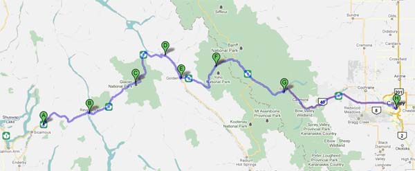
Figure 1: Crossing the Canadian Rockies
A=Yard Creek PP; B=Revelstoke Dam /Visitor Center/Mount Revelstoke NP; C=Glacier NP; D=Donald @Columbia River northbound; E=Golden @Columbia River northbound; F=Field/Yoho NP/BC-Alberta boundary; G=Banff/Banff NP (Alberta); H=Calgary (Alberta)
Now we were witnessing the Canadian side of the vast Columbia River with Columbia Lake as its primary source. The mighty river flows 320 km northwest from Columbia Lake, then takes a steep southward turn at Kinbasket Lake to Mica Creek (pop.700) and flows into the 130 km long Lake Revelstoke, an artificial reservoir formed by the Revelstoke Dam, six km north of Revelstoke (pop. 7,000). Revelstoke Dam is one of the 14 hydroelectric projects on the mainstream of the Columbia River.
(The original highway from Revelstoke to Donald-Golden area followed the Columbia River around the Big Bend to avoid crossing Rogers Pass. We followed the new shortened Trans-Canada Highway 1 built over the pass between 1956 and 1962. This also allowed the construction of Mica Dam, which flooded part of the Big Bend as Kinbasket Lake.)
On the new Trans-Canada 1, we drove through the 26,000-hectare Mount Revelstoke National Park established in 1914. The parkƒÆ’‚¢ƒ¢-¡‚¬ƒ¢-¾‚¢s two boardwalks have been the magnets of tourist attraction: the (500-meter) Giant Cedars Boardwalk interpretive trail that twists through a stand of old-growth western red cedar and hemlock trees, some more than 800 years old; and the (1.2- km) Skunk Cabbage Boardwalk interpretive trail that leads through valley bottom rainforest and fragile wetlands inhabited by muskrats, beavers, bears and the strange skunk cabbage plant (Wikipedia).
Eastbound Canadian Pacific Railway freight train crossing the 600 ft.-long Stoney Creek Bridge, 325 ft. above the creek at Rogers Pass (1988). Source: Wikimedia Commons. Photo by David R. Spencer.]
Next, we headed further northeast to enter the 134,900-hectare Glacier National Park (established in 1886), where we stopped at the Rogers Pass National Historic Site, the location of the parkƒÆ’‚¢ƒ¢-¡‚¬ƒ¢-¾‚¢s visitor center. The site depicts the human history of the region through accounts of first climbs, last spikes, lives lost, and railway lines laid. Excited by the story of how the ferocious avalanches roaring down the Selkirk Mountains at speeds exceeding 300 km an hour caused the Canadian Pacific Railway to abandon its attempt to construct a railway line though the dense wilderness, we decided to walk along the track abandoned in 1910 ready to lay our lives at the mercy of the cosmic forces that decide the timing of avalanches. In1910, while clearing one slide, another slide came down Avalanche Mountain, killing 62 men. Thereupon, the CPR ƒÆ’‚¢ƒ¢-¡‚¬ƒ…-decided that the only way to keep the transportation corridor open was to tunnel under Mount Macdonald thereby eliminating 16 kilometers of the most hazardous railway lineƒÆ’‚¢ƒ¢-¡‚¬ƒ”š‚ (Wikipedia).
Ten glaciated peaks ranging from 2,600 meters to 3,390 meters in height dominate the Glacier National Park, which we left through its East Gate.
Continuing further east on Trans-Canada 1, we crossed the 2,000-km long Columbia River again at Donald (a small sawmilling community) from where we traveled 28 km south along the river to the town of Golden (pop. 3,811), very close to the BC-Alberta boundary.
Golden, nestled in the Rocky Mountain Trench, is located at the confluence of Columbia and Kicking Horse rivers. Three mountain ranges and five national parks surround the town. Columbia Lake, the source of Columbia River, lay 168 km further to the southern end of the trench. Because we had already explored BC for five days, we did not want to spare more time to see the primary source of the river. Besides, we already had a close-up look at the Donald-Golden segment of the northbound first 320-km of the river, which makes an about turn at Kinbasket Lake.
We ate our lunch in Golden, where we also stopped at a bank to get Canadian currency for greenbacks. It dawned on us that we were now on a World Heritage Site recognized as such by Unesco in 1984ƒÆ’‚¢ƒ¢-¡‚¬ƒ¢¢”š¬‚the contiguous national parks of Yoho, Banff, Jasper and Kootenay, as well as the Mount Robson, Mount Assiniboine and Hamber provincial parks. However, because time was running out, we agreed to visit only the spots that werenƒÆ’‚¢ƒ¢-¡‚¬ƒ¢-¾‚¢t too far off from Trans-Canada 1.
Our next stop was Field, the headquarters of the 340,065-hectare Yoho NP (established 1886), 58 km south northeast of Golden. Field is the last outpost of British Columbia with Banff occupying the Alberta side of the border and Yoho the BC side. At Yoho, we went to see the Natural Bridge, a creation of the fast flowing Kicking Horse River; and the Spiral TunnelsƒÆ’‚¢ƒ¢-¡‚¬ƒ¢¢”š¬‚two tunnels that make a gigantic loop inside the mountain. A train headed uphill would enter the lower tunnel and exit on the upper tunnel; and then cross over the lower track on a trestle. The spiral tunnels were necessary to decrease the slope of the track, as it made its way up to Kicking Horse Pass.
An Unexpected Turn
We were about to leave British Columbia when we fell into a traffic trap set up by Her MajestyƒÆ’‚¢ƒ¢-¡‚¬ƒ¢-¾‚¢s BC Provincial Police to make a fast buck. We drove downhill on Trans-Canada 1 from Watson Peak to Lake Louise with several vehicles trailing us. Traffic law did not permit overtaking on the highway marked with double solid lines. An elderly couple driving ahead of us at slow speed held up the smooth flow of traffic spreading impatience among the drivers who began to honk their horns. Yoke-Sim egged me on to overtake the vehicle of the elderly couple. Little did I know that the royal constabulary was waiting for me at the foothills to pull me up and express the displeasure of Her Majesty for violating BC traffic laws. Officer S. Crowe, God bless him (I still remember his name!), issued me a warrant to appear in the traffic court or pay a fine of $75.
Touring Alberta
That sour experience made me happy to leave British Columbia behind and enter the province of Alberta (pop. 3.7 million), the most populous of the three prairie provinces that we had to travel through on this journeyƒÆ’‚¢ƒ¢-¡‚¬ƒ¢¢”š¬‚the other two being Saskatchewan and Manitoba. Alberta is named after Princess Louise Caroline Alberta (1848ƒÆ’‚¢ƒ¢-¡‚¬ƒ¢¢”š¬…”1939), the fourth daughter of Queen Victoria and Prince Albert. People who identify themselves as British (47.5 percent) or Canadian (20.5 percent) make up more than two-thirds of the population. Calgary (pop. 1.1 million) is AlbertaƒÆ’‚¢ƒ¢-¡‚¬ƒ¢-¾‚¢s largest city. Edmonton (pop. 730,372) is the provinceƒÆ’‚¢ƒ¢-¡‚¬ƒ¢-¾‚¢s capital.
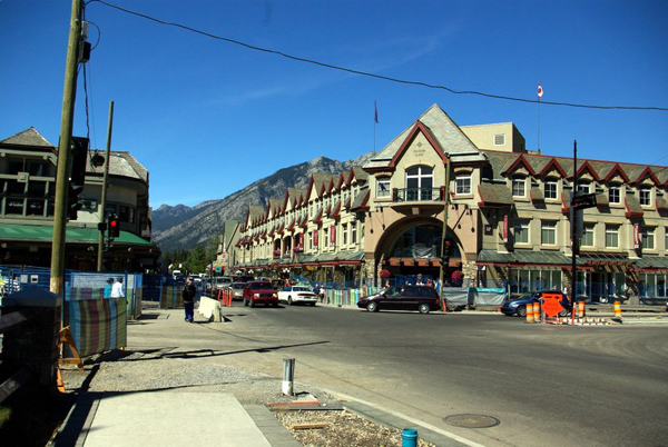
Banff, Alberta (2007).
Source: Wikimedia Commons. Photo by Jiri Eischmann.]
After entering Alberta, we hopped over to the 1.7 million hectare Banff National Park, the oldest national park of Canada established in 1885, two years after the discovery of the thermal mineral springs exhibited at the Cave and Basin National Historic Site. It constitutes the lowest component of nine sulphurous hot springs clustered in three groups on the northeast flank of Sulphur Mountain. We also visited the beautiful Cascade Rock Gardens encircling the Park Administration Building. A trail winding through the terraced garden passes through arches, gazebos with seats, and blooming patches of flower and manicured lawns. At various turns are views of the surrounding mountains.
From Banff (pop. 8,721) town, we drove 129 km east to Calgary, where we arrived about 8 p.m., Mountain Time. Our driving distance for the whole day was 520 km. We checked into Windward Hotel (119 12th Ave. SW) for the night.
(To be continued)


