The Travels of a Journalistâ€â€ÂÂ64 From Calgary to Regina: Exploring Canadian prairie
Posted on April 2nd, 2011
By Shelton A. Gunaratne ƒÆ’-¡ƒ”š‚©2011Professor of mass communications emeritus@ Minnesota State University Moorhead
The four of usƒÆ’‚¢ƒ¢-¡‚¬ƒ¢¢”š¬‚daughter Carmel, 5; son Junius, 9; wife Yoke-Sim and IƒÆ’‚¢ƒ¢-¡‚¬ƒ¢¢”š¬‚spent Saturday (2 Sept. 1989) morning to get a sense of Calgary, located in the Grassland region of southern Alberta. Two major rivers run through the city. The Bow River is the largest and flows from the west to the south. The Elbow River flows northwards from the south until it converges with the Bow River near downtown.
In 1883, the Canadian Pacific Railway reached the area and built a rail station in Calgary, which soon turned into an important commercial and agricultural centre. The CPR headquarters are located in Calgary today. After the arrival of the railway, the dominion government adopted the policy of leasing grazing land at minimal cost (up to 40,470 hectares for 2.5 cents per hectare per year). This policy enabled the establishment of large ranching operations in the outlying country near Calgary.
Already a transportation and distribution hub, Calgary quickly became the center of Canada’s cattle marketing and meatpacking industries. The world famous Calgary Stampede, still held annually in July, grew from a small agricultural show and rodeo started in 1912 by four wealthy ranchers to “the greatest outdoor show on earth” (Wikipedia).
With the discovery of oil in Alberta, CalgaryƒÆ’‚¢ƒ¢-¡‚¬ƒ¢-¾‚¢s economic ups and downs began to reflect the highs and lows of the oil industry. Today, while the oil and gas industry comprise an important part of the economy, Calgary city has invested a great deal into other areas such as tourism and high-tech manufacturing.
Our plan for the day was to continue east on Trans-Canada 1, cross the prairies into adjoining Saskatchewan, and stay overnight in Regina, the provincial capital of Saskatchewan. The distance between Calgary and Regina is 758 km. (But, at the end of the day, our deviations from Highway 1 caused us to drive more than 63 km extra.)
Morning in Calgary
We spent the morning getting to know downtown Calgary. Just three blocks to the north of Windward Inn where we spent the night, we gawked at the 191-meter Husky Tower (101 Ninth Ave SW) built at a cost of $3.5 million in 1967. In 1971, it was renamed Calgary Tower, notable for its revolving restaurant and its carillon. The 215-meter Petro-Canada Centre’s west tower overtook the Calgary Tower as the tallest structure in Calgary in 1983.
Next, we found our way to the Fort Calgary Interpretive Centre on Ninth Avenue SE at the confluence of Elbow River with the bigger Bow River. The North-West Mounted Police established the fort in 1875 to comply with a federal order to force out whiskey traders from the area. Originally called “The Elbow” or “Bow Fort,” the fort made of pine and spruce logs was eventually named after a castle at Calgary Bay on ScotlandƒÆ’‚¢ƒ¢-¡‚¬ƒ¢-¾‚¢s Isle of Mull. The fort was in operation until 1914.
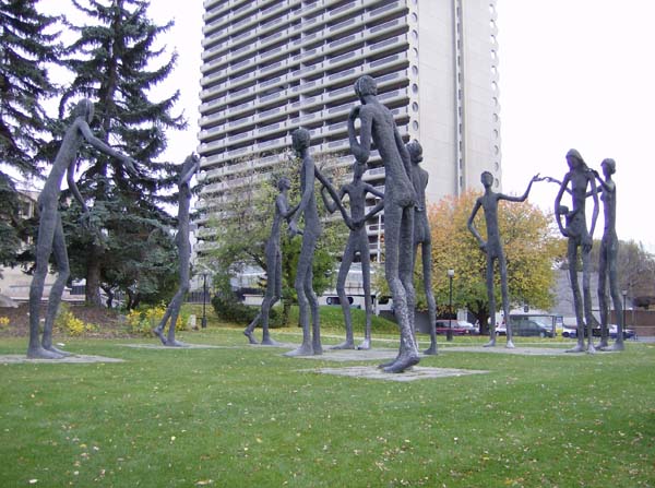
Backtracking to downtown, we stopped at the Calgary Education Centre (515 Macleod Trail SE) to see the set of statues called ƒÆ’‚¢ƒ¢-¡‚¬ƒ…-The Family of ManƒÆ’‚¢ƒ¢-¡‚¬ƒ”š‚ that sculptor Mario Armengol (1909-1995) built for Britain’s Pavilion at Expo ƒÆ’‚¢ƒ¢-¡‚¬ƒ”¹…”67. Maxwell Cummings & Sons purchased the 6.4-meter tall metal statues and donated them to the Canadian Board of Education for public exhibition.
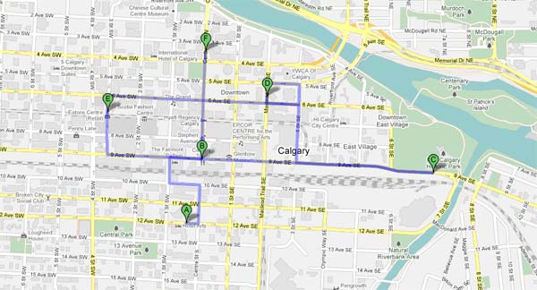
Figure 1: Sites we visited in Calgary, Alberta (2 Sept. 1989)
A=Windward Inn; B=Calgary/Husky Tower; C=Fort Calgary Historical Park@ confluence of Elbow River with Bow River; D=ƒÆ’‚¢ƒ¢-¡‚¬ƒ”š‚The Family of ManƒÆ’‚¢ƒ¢-¡‚¬ƒ”š‚ sculpture exhibit; E=Devonian Gardens@ The CORE Shopping Center; F=Chinatown
Then, we visited the one-hectare Devonian Gardens, a large indoor park and botanical garden located on the Stephen Avenue pedestrian mall. The park is completely enclosed with glass and covers one full city block on the top floor of The Core Shopping Centre, which was known as the Toronto Dominican Shopping Complex at the time of our visit. Opened in 1977, the construction of the project cost $9 million. (This attraction was scheduled to re-open in 2011 after its closure in 2008 for a major reconstruction.)
ƒÆ’-¡ƒ”š‚
ƒÆ’‚¢ƒ¢-¡‚¬ƒ…-The Family of ManƒÆ’‚¢ƒ¢-¡‚¬ƒ”š‚ sculpture exhibit in downtown Calgary, Alberta (6 Oct. 2006).
Source: Wikimedia Commons. Photo by Thivierr]
Finally, running short of time, we drove through CalgaryƒÆ’‚¢ƒ¢-¡‚¬ƒ¢-¾‚¢s Chinatown district (pop. 1,361), the fourth largest in Canada, on our way to rejoin Trans-Canada 1 for the dayƒÆ’‚¢ƒ¢-¡‚¬ƒ¢-¾‚¢s long journey east. We found Chinatown along Centre Street in the northeast area of Downtown Calgary immediately north of the Downtown East Village. We ate lunch at a restaurant in Chinatown. Wikipedia attests that Calgary’s Chinese Cultural Centre with its traditional architecture and decor (styled after the Temple of Heaven in Beijing) is the largest facility of its kind in North America.
Back on Trans-Canada 1
After leaving Calgary, our first stop on Trans-Canada 1 was Brooks (pop. 12,498), about 186 km to the southeast. Located in the steppe region known as the Palliser’s Triangle, Brooks has a semi-arid climate, which produces long, dry and cold winters with little snowfall in comparison to the rest of Canada. We visited the Alberta Special Crops and Horticultural Research Centre, where we toured the rose garden and the perennial flower trials. However, to the dismay of Carmel and Junius, the wildlife centreƒÆ’‚¢ƒ¢-¡‚¬ƒ¢-¾‚¢s pheasant-raising facility was closed for the day.
Figure 2: From Calgary to Regina (758 km)
A=Calgary, AB; B=Brooks, AB; C=Medicine Hat, AB; D=Walsh, AB; E=Maple Creek, SK; F=Swift Current, SK; G=Herbert, SK; H=Chaplin, SK; I=Moose Jaw, SK; J=Regina, SK
Thereafter, we ƒÆ’‚¢ƒ¢-¡‚¬ƒ…-exploredƒÆ’‚¢ƒ¢-¡‚¬ƒ”š‚ the prairies with brief stops in rhe following communities:
ƒÆ’‚¢ƒ¢-¡‚¬ƒ”š‚¢ Medicine Hat (pop. 61,097), 107 km southeast of Brooks. Well known for its natural gas fields, it is also called ƒÆ’‚¢ƒ¢-¡‚¬ƒ…-The Gas City.ƒÆ’‚¢ƒ¢-¡‚¬ƒ”š‚ We stopped at a downtown park for refreshments. The Badlands Guardian Geological Feature, a landscape formation taking the form of a head wearing a feathered headdress, lies 40 km to the east of the city.
ƒÆ’‚¢ƒ¢-¡‚¬ƒ”š‚¢ Walsh (pop. 55), about 53km east of Medicine Hat. This hamlet lies immediately to the west of the Saskatchewan border.
ƒÆ’‚¢ƒ¢-¡‚¬ƒ”š‚¢ Maple Creek (pop. 2,198), about 53km east of Walsh. It is the town in Saskatchewan closest to the Alberta border. We stopped at the Tourist Information Centre, where a friendly guide helped us with the tourist literature we needed.
ƒÆ’‚¢ƒ¢-¡‚¬ƒ”š‚¢ Swift Current (pop. 15,048), 138 km northeast of Maple Creek. It was 8.30 p.m. when we reached Swift Current where we bought gasoline and our food. We ate dinner at a quiet spot along a downtown street. Yoke-Sim took over driving from here to Regina.
ƒÆ’‚¢ƒ¢-¡‚¬ƒ”š‚¢ Herbert (pop. 742), about 47 km northeast of Swift Current. The Herbert Train Station Museum is ƒÆ’‚¢ƒ¢-¡‚¬ƒ…-the best place to stop for information on the town of HerbertƒÆ’‚¢ƒ¢-¡‚¬ƒ”š‚ (Wikipedia).
ƒÆ’‚¢ƒ¢-¡‚¬ƒ”š‚¢ Chaplin (pop. 292), about 44 km east of Herbert. In 1997, Chaplin Lake was designated a Western Hemispheric Shorebird Reserve Network siteƒÆ’‚¢ƒ¢-¡‚¬ƒ¢¢”š¬‚the highest designation that a reserve can receive.
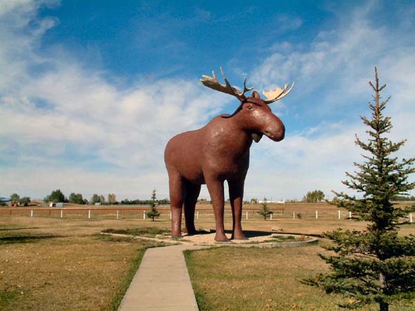
ƒÆ’‚¢ƒ¢-¡‚¬ƒ”š‚¢ Moose Jaw (pop. 35,629), 85 km east of Chaplin. Its intriguing name was the reason we stopped in this city. Some say that the city derived its name from the shape of the Moose Jaw River. Others say that the name is a corruption of the Plains Cree word moscƒÆ’†’ƒ”š‚¢stani-sƒÆ’†’ƒ”š‚®piy (meaning “a warm place by the river”). The replica of ƒÆ’‚¢ƒ¢-¡‚¬ƒ…-Mac the MooseƒÆ’‚¢ƒ¢-¡‚¬ƒ”š‚ standing on the edge of the city reminded me of ƒÆ’‚¢ƒ¢-¡‚¬ƒ…-Max the Moose,ƒÆ’‚¢ƒ¢-¡‚¬ƒ”š‚ the emblem of Dryden, Ontario, that we saw as we traversed Trans-Canada 17 in 1988 (see Travels-49).
We arrived in Regina, 75 km east of Moose Jaw, close to midnight after crossing a long stretch of the prairies. Carmel and Junius helped me set up our tent on a site at the KingƒÆ’‚¢ƒ¢-¡‚¬ƒ¢-¾‚¢s Acres Campground, 1km east of Regina on East Gate Drive.
Our tired bodies were only too willing to yield to the call for sleep. Yet I could hear the sound of raindrops falling on our tent as we curled up in our sleeping bags intent on disregarding such minor distractions of Nature.

ƒÆ’‚¢ƒ¢-¡‚¬ƒ…-Mac the MooseƒÆ’‚¢ƒ¢-¡‚¬ƒ”š‚ stands on the edge of Moose Jaw, Saskatchewan (10 June 2008)
Source: Wikimedia Commons. Photo by Magnus Manske]
(To be continued)


