Parakrama Samudraya, 1978 flood, and strength of tank bund
Posted on September 7th, 2021
By Palitha Manchanayake Courtesy The Island
Former Irrigation Engineer, Sri Lanka and Hydrologist/Flood Forecaster to the Commonwealth Bureau of Meteorology, Sydney, Australia In this article, the author wishes to highlight his experience during the November 1978 cyclone, while working as an Irrigation Engineer (IE) attached to the Hydrology branch of the Irrigation Department, Sri Lanka.
That particular morning, Tilak Nikapitiya (IE) and I were called in by late Olsen Gunawardane, Senior Deputy Director (Research), to his office and asked us to take a ‘Four-Wheel Drive’ and proceed to Polonnaruwa immediately to meet A.D.S. Gunawardane (IE, Polonnaruwa). We were also expected to rescue and look after the Hydrological Field Unit and the Drilling Team of the Engineering Geology Division who had got marooned in the flood while working in the Maduru Oya area. Before leaving, Gunawardane showed us a photograph that had appeared on page one of the Ceylon Daily News on that day. It had been taken from a helicopter hovering above the Parakrama Samudraya .It showed the flood waves of Parakrama Samudraya overtopping its bund in many places. The Parakrama Samudraya Reservoir was at full capacity, and the water level was quite close to the bund top. Owing to the reservoir’s long fetch of water-spread and the high wind velocities that prevailed during the cyclone, the flood waves generated at the surface were overtopping the reservoir bund.
The author recollects that he had never encountered such a drastic and serious situation during his entire 49-year career as an Irrigation Engineer/Hydrologist. It was an alarming and critical situation considering the danger to the large population living in Polonnaruwa suburbs located below the Parakrama Samudra.
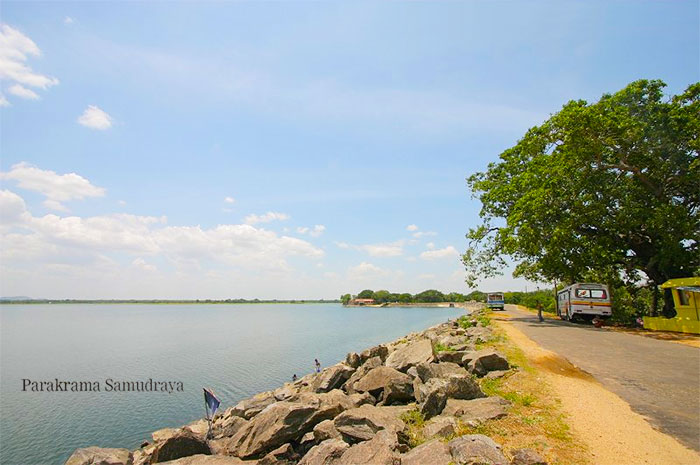
The Parakrama Samudraya Reservoir was built by King Parakramabahu the Great, during his reign (1153-1186 AD) and it has a capacity of 98,000 acre-feet, feeding approximately 18,200 acres of paddy cultivation. This reservoir has a tank bund,which is 52 feet high and nine miles long. When the reservoir is full, the entire nine-mile long bund is tested. It is an earthen dam constructed by the ancient Sri Lankan dam builders about 1,000 years ago.
If an earthen dam is to be built today, one has to follow the principles of soil mechanics, and adhere to the criteria involved in selecting the particular type of soil to be used in construction and the identification of suitable borrow areas for them, and maintaining the required standards of compacting and consolidating the soils. In this process, the mere ramming of soil would not do. It has to be done with the appropriate addition of water so that the maximum soil density is achieved through the optimum soil-moisture content. In the present day, this is achieved by compacting the soil with sheep-foot rollers and performing the ‘in-situ’ soil tests on site. But when the reservoir is on the verge of being overtopped by flood waves, it, in fact, tests the soil mechanics and the compaction techniques adopted using cattle and elephants done in ancient times. If there was a portion of earthen bund of poor quality it could fail and the dam could breach at that point. If this impending dam break happens at an unwanted and unexpected point on the dam, it could be disastrous and devastating, as so many civilians and property downstream of Parakrama Samudra would be seriously affected.
Knowing the imminent catastrophic danger, the Irrigation Engineer (IE) in charge of Polonnaruwa, A.D.S Gunawardane, the Government Agent (GA) Polonnaruwa, Austin Fernando, and a few other officials on duty, decided to get over a few bulldozers and retain them at the sluice and spillway sites, to breach the dam at these points if the need arose. The idea behind it was, if the predicted overnight rainfall occurs and the anticipated inflow to Parakrama Samudra does eventuate, then an artificially introduced breach of the dam at one of these particular outlets would enhance the draining of the floods along the already existing channels, rather than haphazard catastrophic flood damage occurring at an unwanted point over the downstream townships. In doing so, the ‘flood operation team’ would be controlling the flood somewhat, minimising damage to life and property, but the IE would be facing the danger of not being able to continue the issue of water to about 18,000 acres of paddy cultivation which was halfway through the Maha Season. Because of this artificial breaching of the dam, no water would be retained in the reservoir as it would completely empty. As such, it could result in crop failure of a vast acreage, which would be a significant political issue. Farmers who have invested their money in land preparation, seed-paddy, weedicide and pesticides would end up desperate and without any income, possibly creating farmer unrest in the area.
As such, the flood operators were very reluctant to go through with the breaching option unless they were left with no alternative. Yet another unknown factor was how much of the predicted rainfall would occur overnight in the already wet 28 square-mile catchment of Parakrama Samudraya , in addition to whatever inflow that came through Amban Ganga. So, after much deliberation that night, the ‘flood operation team’ decided to stay overnight leaving all sluice and spillway gates open, anticipating the predicted rain to fall over the catchment.
At dawn the following morning, a completely unexpected phenomenon was evident. Even though the reservoir water levels did not overtop the bund and were under control, the anticipated overnight rainfall had not really eventuated, and because the sluice and spillway gates were kept open overnight, the water levels had gone down drastically, causing ‘slip circle failures’ in the dam at many places along the entire stretch of the dam.
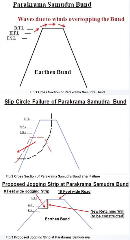
Even though there was a 12-foot wide roadway at the crest of the dam, a fair portion of the dam had caved-in with earth slips slumping into the reservoir, leaving only about a four-foot-wide section of the former roadway intact (Figure 2). This could be explained in engineering terms as ‘slip circle failures caused by the sudden drawdown of the water table. The increased pore water pressures of the soil have caused these slips to occur’. It was inevitable, as there were predictions of more overnight rain in the catchment which required due consideration, and there was no way of monitoring the inflow to Parakrama Samudraya at that late hour of the night. This happened in Polonnaruwa, Sri Lanka in November 1978.
The Parakrama Samudraya had to be restored by re-constructing the entire stretch of the damaged bund, which resulted in a major exercise of dam construction. It was re-done with a much broader roadway at the dam crest, and also with big rock boulders in rip-rap to serve as wave-breakers in future.
In this ‘flood operation’ exercise of November 1978, all of 18,200 acres of paddy cultivation was saved, as the Parakrama Samudraya Reservoir was able to issue the required water for the rest of the Maha Season. Luckily, the much-feared disastrous breaching of the bund did not happen. It was indeed a revealing experience for all the Irrigation Engineers of the present day, who manage the ancient reservoirs built by Sri Lankan Kings. On further reflection, one could argue that had we taken the option of artificially breaching the dam bund at a sluice or spill site, we would have overcome the flood dissipating problem easily with a lesser cost of dam construction, but ended up with devastating crop failure of 18,200 acres of paddy cultivation.
What is amazing is that the nine-mile-long earth bund of Parakrama Samudraya stood strong without breaching against the force and the head of water generated by the cyclone, giving full credit to King Parakramabahu the Great and his men.
These were the sort of risks, problems and threats we were faced with when handling the 1978 flood event.
If the eight-foot-wide jogging strip (as proposed in Figure 3) were to be constructed, then it should be at least three feet below the Bund Top Level (B.T.L), in which case a retaining wall of some sort has to be built to ensure the safety of the 16-foot-wide roadway at the top. The construction of this retaining wall could be of concern with the existing structure of the earthen bund.
One case that comes to mind is how late R. Premadasa (then Prime Minister and the Minister of Local Government) around the 1985/86 period, installed a Pumping Station on top of the old Kantale Bund to provide drinking water to the nearby town. After operating the huge pumps for some time, the Bund failed due to the vibrations of continuous pumping. But in the case of the jogging strip at Parakrama Samudraya , one could expect minimal vibrations.
Some point out that no problems have been reported regarding the jogging track at Tissa Wewa in Tissamaharama, built in 2014. At Tissa Wewa, the road is by the side of the lake with a low bund height of about 15 ft. But in the case of Parakrama Samudra, the tank bund is higher, and it is a completely different scenario.
One more important aspect of the new construction that merits discussion is the non-existence of the rip-rap. They say that they are going to roll the big rock boulders downward. The big rock boulders or the rip-rap is actually there to break the waves that occur when the reservoir is operating with water levels above the High Flood Level (H.F.L). The Full Supply Level (F.S.L) generally corresponds to the Full Operating Capacity of the Reservoir. During a special situation, when a flood occurs while the water level remains at F.S.L., the radial gates would be opened. At the point when this flood passes through the spillway system with all its gates open, the extra lift of the water level of the reservoir is called the ‘Flood Lift’. In Sri Lankan reservoirs, the ‘Flood Lift’ is generally calculated for a flood event of 1 in 100-year frequency. This ‘Flood Lift’ is the basis to decide on the H.F.L. of the reservoir. The difference between the H.F.L. and the Bund Top Level (B.T.L) is referred to as the ‘Free Board’ which accounts for the waves that are generated at the surface of the reservoir. The rip-rap which consists of the big boulders is there to break the waves, and it has to be placed between the H.F.L and B.T.L of the reservoir. So, if they are going to roll the big boulders below the H.F.L with the new construction, the purpose would be lost, and if a flood event like the one in 1978 occurs again, there would be one less defence mechanism for wave-breaking, which could be awful.
Therefore, I do not think that it is advisable to do any sort of alteration, meddle with or disturb the good old bund.
(The writer is a former Irrigation Engineer, Sri Lanka and Hydrologist/Flood Forecaster to the Commonwealth Bureau of Meteorology, Sydney, Australia)
September 8th, 2021 at 1:24 pm
Interesting article. Never knew Parakrama Samudraya has only 28 sq.miles. And how does he think our ancients would have calculated the runoff from such an area and got the height so accurately that even after a thousand years the bund stood the test. And how are the Irrigation Engineers of today do their calculations without rainfall intensity charts or isopleth maps?. Do we have manuals giving guide lines or specifications?. I do not think so.
I too have done a design of a dam of about 15m high (as I can remember with electrically operated gates) not to store water but to serve as a detention pond for a flood protection of villages and a town. As I did not have any idea of building dams I had to search for material all over the place. I got three books, one from Australia for building of small dams, one book on soils an excellent one by Eng. Garg from India. Armed with soil compaction in road building, I was able to finish it in record time doing compaction according to British Standards. It has become a leisure spot as in many places for the folks in the area to come with their families in the evenings. Luckily for me I had a software by the name HEC-1 (perhaps the first software developed by US Army corps of Engineers). I had to search high and low for the curve numbers to use as parameters for this software as they are not used in that country.
AS for the gradients of the Yoda Ela etc. I feel they are the minimum natural gradients of rivers. This is what I got when doing a major flood protection work in the same country on another river about a kilometer wide. Our ancient engineers may have used some thumb rules. When flying over Malaysia I have observed that all those big rivers meander a lot just before reaching the sea, perhaps to slow down and allow the nutrients to get absorbed in the river banks. In other cases the river splits into many branches before reaching the sea. River Niger is one where it forms a delta before meeting the sea.
September 8th, 2021 at 1:29 pm
Please correct the first line as “…..has only 28 sq.miles as catchment.”