The unsolved mystery of Sri Lanka’s ‘Stargate’
Posted on May 2nd, 2021
By Demi Perera Courtesy BBC
In recent years, the internet has been alight with speculation that a chart-like carving in Anuradhapura is a stargate: an ancient gateway through which humans can enter the Universe.
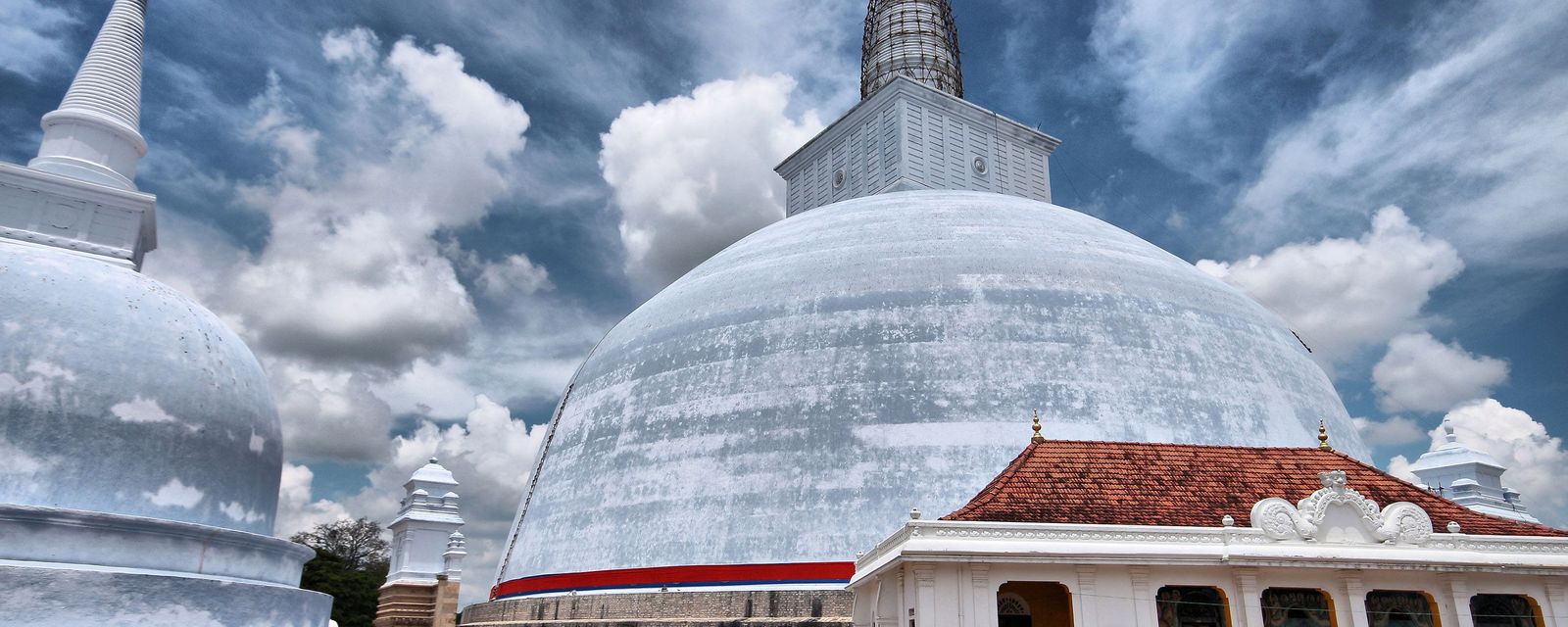
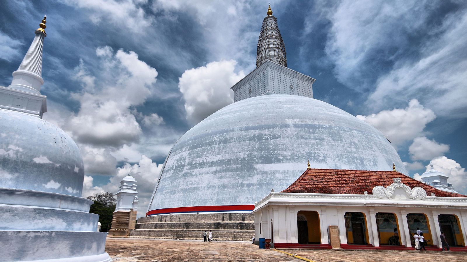
Sri Lanka’s sacred city of Anuradhapura is an unlikely place to be enmeshed in a fantastic tale of UFOs and otherworldly happenings. Locally known as Rajarata (Land of Kings), the Unesco World Heritage Site was the first established kingdom on the island (in 377 BC) and is at the heart of Sri Lanka’s Buddhist culture. Today, it’s one of the nation’s most visited places, attracting devoted pilgrims from around the country to its ancient Buddhist temples and giant dome-shaped stupas.
But this holy city is also home to something far more curious. Here, in Ranmasu Uyana (Golden Fish Park), a 40-acre ancient urban park surrounded by three Buddhist temples, is a chart that’s alleged to be a map to unlock the secrets of the Universe.

The Sakwala Chakraya has been variously interpreted as a cosmographical chart, a stargate and a building plan (Credit: Demi Perera)
Measuring around 1.8m in diameter, Sakwala Chakraya (which translates to “Universe Cycle” in Sinhalese) is shallowly carved onto a low rock face among the protected park ruins. Its front facade can only be seen from ground level. In fact, four seats have been sculpted into a flat rock surface opposite that provide the ideal viewing area. Both the map and seats, which are also of mysterious origin, have puzzled historians, archaeologists and academics for more than a century.
Its existence, function or anything related to it is not mentioned in any historic records
“Ranmasu Uyana was used for a prolonged period in history,” said Professor Raj Somadeva, senior professor of archaeology at the University of Kelaniya, Sri Lanka. “The second major developmental phase seems to have begun in the 7th Century CE. During that period, several new buildings were added to the earlier garden layout. The chart could be a work of this period, but it’s impossible to know because its existence, function or anything related to it is not mentioned in any historic records, which were meticulously kept by Buddhist monks.”
While little is known about the chart and its purpose, the iconography is incompatible with other carvings of the Anuradhapura period (3rd-10th Century AD). The chart’s centre is made up of seven concentric circles divided by parallel vertical and horizontal lines. Rectangular compartments contain small, crossed circles. To the untrained eye, there are figures resembling umbrellas or bow and arrows, a kite, wavy lines and cylindrical shapes. An outer ring depicts marine animals: fish, turtles, seahorses.
When compared to other carvings from the same period such as the Sandakada Pahana, which depicts vines, swans and a lotus, all typical of Buddhist iconography, the chart is without religious context, leaving it without an obvious explanation as to why it is here.
Sri Lanka’s sacred city of Anuradhapura was the first established kingdom on the island (Credit: AnaG/Getty Images)
This has left it wide open to online speculation. Before the dawn of the internet, the chart garnered little attention in Sri Lanka. It is thought to have survived here, tucked away at the edge of a boulder, after the fall of the Anuradhapura kingdom; unremarkable in comparison to its breath-taking surroundings complete with twin ponds and bathing pavilions believed to have been used by kings. In fact, if aliens did arrive on Earth through here, they couldn’t have picked a nicer place – these sacred temple grounds, cloaked in thick, tropical jungle, are mostly uninhabited and protected by the authorities.
The first academic to note the chart’s archaeological importance was H C P Bell, a British civil servant appointed as the first Commissioner of Archaeology of Ceylon (Sri Lanka’s former name). Bell included a description of the chart in his 1911 report for the Governor of Ceylon, where he concluded that, “This ancient ‘map of the world’, perhaps the oldest in existence, is of quite extraordinary interest. Its presence… testifies to the antiquity of that astronomical lore still pursued in some of the Buddhist monasteries of Ceylon.”
While the chart does not resemble a map in a modern sense, Bell wrote that it depicts “an old-time cosmographical chart illustrating in naivest simplicity the Buddhistic notions of the universe”. He interpreted the circles, the symbols and marine life on the chart, based on his knowledge of Buddhism on the island, to mean the Earth, the seas, outer space and the Universe.
While discussions around the chart for many years were mainly confined within academic circles due to its historically important location, the explosion of photo-sharing on social media over the last few years has shone a global spotlight on the mystery. Eagle-eyed tourists have remarked on parallels between the chart in Anuradhapura and similar sites in other countries that are believed by some to be stargates – ancient gateways through which humans could enter the Universe. Their theory goes that the chart holds the secret code for unlocking the portal.
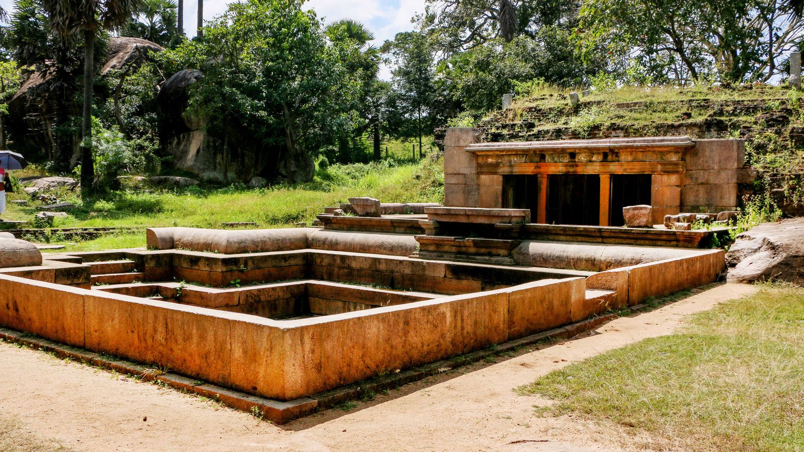
Ranmasu Uyana is a 40-acre ancient pleasure garden that includes the ruins of bathing pools (Credit: Sri Lanka Tourism)
Conspiracy theorists noted that the stargate of Anuradhapura had near-identical shapes and symbols to those found at Abu Ghurab in Egypt and La Puerta de Hayu Marka in Peru. The most striking similarity, it was said, as speculation around Sri Lanka’s stargate reached its peak, is its proximity to water. The nearby Tissa Weva reservoir, built in 300 BC, has been thrown around as conclusive evidence, since both Abu Ghurab and La Puerta de Hayu Marka were also built near water, which, according to the stargate theory, allowed extra-terrestrial beings to process gold from Earth’s water.
You may also be interested in:
• The US’ lost, ancient megacity
• Where you can see the soul of the Earth
• A mystery in Asia’s forgotten desert
This otherworldly theory has been further fuelled by the chart’s proximity to Danigala mountain, also known as Alien Mountain, in the nearby sacred city of Polonnaruwa. Danigala, which lies deep in the jungle and is popular with hikers, has a unique circular shape and entirely flat top. This led internet sleuths to conclude that it must have, at one time, been used for UFO landings. Strangely, according to Sri Abeywickrama, a local tour guide, “villagers in the area do believe that Alien Mountain attracts more shooting stars and thunder and lightning above it than anywhere else.”
However, according to Somadeva, “There is little archaeologically to suggest that it’s a stargate.” Instead, Somadeva believes a more sensible conclusion is that the chart is an early map of the world, as suggested by Bell, because that explanation has religious and cosmological context that is logical, given the period and place in time.
According to Somadeva, “At least since 250 BCE, Sri Lankans had a clear idea of objects in the sky and outer space. In early Brahmi inscriptions, found in Sri Lanka, there are a number of names that refer to specific stars and concepts related to astronomy. One of the inscriptions in Kirinda, a religious and historic site on Sri Lanka’s southern coast, contains the phrase ‘aparimita loka datuya‘ meaning ‘the infinite universe’. What it suggests is that the person who engraved it had a very good understanding of the nature of the universe they lived in.”
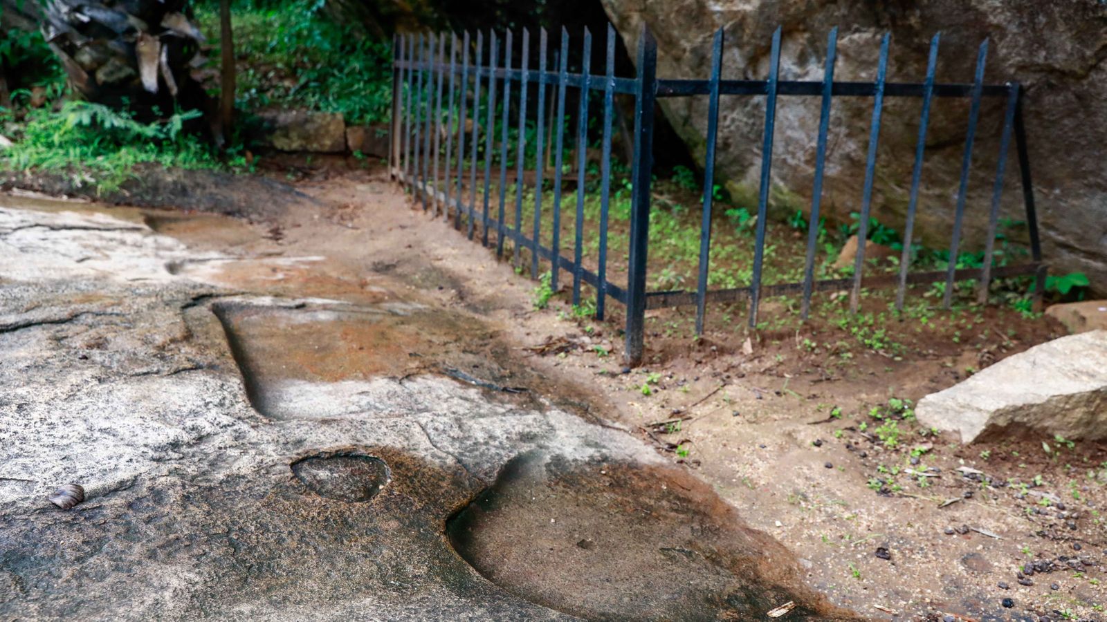
Opposite the chart, four seats sculpted into rock provide an ideal viewing area (Credit: Demi Perera)
However, Shereen Almendra, senior lecturer of landscape design at the University of Moratuwa, Sri Lanka, offers a different, more earthly perspective. “I think the Sakwala Chakraya chart is a plan for a complex project similar to the enormous stupas that were being built at the time,” she said. “I lean towards it being a plan for Sigiriya.”
Sigiriya is one of Sri Lanka’s most recognised ancient landmarks, a 5th Century BC rock fortress, complete with flowing water, landscaped gardens and multiple living quarters. It lies just half an hour away from Anuradhapura within Sri Lanka’s Cultural Triangle, which is made up of three important ancient cities: Anuradhapura, Polonnaruwa and Kandy. “Given that the three seats carved in front of the chart appear to slightly face toward each other, it makes me think that it was a place for discussion – an ancient architect’s office if you like,” she said. “If the seats were built for a religious purpose, such as meditation, they would be in a straight line instead.”
According to Somadeva, the greatest challenge in identifying the function of the chart has been the lack of evidence to correctly date it. While Ranmasu Uyana and other parks and stupas in Anuradhapura are mentioned in chronicles and inscriptions dating as far back as 250 BC, the Sakwala Chakraya is not described in any historical records. “There would definitely have been a practical use for this diagram but it’s a huge challenge to figure out what that might have been when we can’t correctly date it,” he said.
So it seems that Sri Lanka’s enigmatic alleged stargate remains shrouded in mystery, its purpose and meaning still lost to time. The chart’s newly acquired cult status amongst sci-fi enthusiasts, however, has finally given it some well-deserved public attention. Thanks to their enthusiasm and the power of social media, it has finally stepped out of the shadow of larger-than-life Anuradhapura to stand apart on its own.
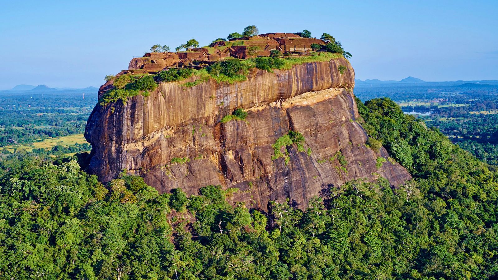
One expert suggested the chart may be a building plan for nearby Sigiriya, a 5th Century BC rock fortress (Credit: Anthony Asael/Art in All of Us/Getty Images)
May 3rd, 2021 at 5:14 am
Just like UK is (probably) the center of today’s digital technology, this region was the center of astrology which has a one to one relationship with astronomy. Please listen to a recent video of DR. Suriya Gunasekara (retired civil servant of Ceylon) on Sinhala new year.
According to him Mannar (which is a adaptation of Sinhala words Manu Arama meaning center of measurements) is the center where the sun comes directly overhead in March each year or ephamerical equinox. He says he actually measured it once by planting a stick on the ground on the particular day. And he says our ancients (even before Vijaya came) have known about it and divided the circle to 360 degrees and assigned each sector of 15 degrees to a symbol like Aries etc. And the new year that follows immediately after was celebrated by the locals as their new year. It was the Brits who converted it to Sinhala and Hindu to satisfy the Tamils.
Why I consider UK to be digital center of the world: take the smart mobiles phones we all use for example. Do we know that we cannot exit an app on any of these devices whether Android or iOS (Apple)?. Some of the data that we use in the apps by clicking on it lives on their memory until we switch the device off. Currently 95% of mobile phones use the ARM which is British technology. So, does it mean someone is listening to us all the time?.
Do not forget that the computer itself is a product of their attempts to prepare charts for navigation 200 years ago. And it was they who built the Colossus to decode the communications of U-boats and perhaps as a result won the WW2.
I would like to have a comment by a top ICTA guy.
May 3rd, 2021 at 7:10 am
Aloy
UK gave the start to the digital technology where in early 1970 with the help of the research dept. and British companies who made the modules mad the pcm system where the system sampled the analogue sine wave in ti digital signal where it was regenerated every 1850 feet or yards, some times in the street.In the beginning we transmitted 12 telephone messages simultaneously on a copper wire which was meant for one telephone message.Then it it increased to 24,48 and 64,there after we used coax and optical laser technology.by that time I was not working in the field but behind the desk controlling the projects.
If there’s need to listen the possibility is there for likes of us in the highly developed country where ones key words will give some attention. Technology is advance enough to locate your presence in any part of the world which have the mobile system.Now I am well into retirement have little time to remember they system, only feed backs I get from my colleagues who are still at it.Some on in US had made a mechanical computer in 1800s like the old mechanical cash machine which is not digital. We seem to give every thing away to other countries. I worked so hard as a technical officer in the field to set up the equipment at the masts where I was severely injured by a mugger who tried to grab my big mobile phone, which had a nick name a brick which was that big, thanks to the local police who took me to the hospital I would not me writing this. ^There was a great effort made my us to set up the mobiles and the INTRANET for banks and other big companies who wanted to be linked to their nation wide and world wide offices and connections and but when the system shared the digital high ways with others lead to world wide network(w.w.w).Too busy must push off.
May 3rd, 2021 at 8:42 am
Sorry about my grammar, didn’t have the time to go through it as usual, too busy.
May 3rd, 2021 at 11:20 am
Nimal,
It is through my own experience that I have put down what I wrote in the 3rd para above. I found this while debugging my own Android app for the analysis of sewerage systems. Though it gave me exactly the same results as an expensive desktop software application costing thousands of dollars, by a well known US company, when pressing the ‘home’ button to exit I found that the app retains the status of some pages of it I visited earlier. This method of exit is called unwinding the stack. I spent several hours trying to find what the problem is, to see that it is an inherent problem of the system, according to Google engineers who discuss these in a website called ‘Stack overflow’.
BTW, many of them seem to be Indians and I feel very sorry for the state their country is in today.
May 3rd, 2021 at 8:49 pm
It would be better if both Bill Gates (whose divorce was just announced) and Tim Cook (Apple stands trial today in the US courts on App Store issues) get their charts read again (the astrology mention in my post above) to see how strongly they stand.
It seems the stars reset every 73 years to their original position!.
Any relevance of this reset for the destiny of our country?.
Comments on this welcome!.
May 4th, 2021 at 10:33 am
Aloy
If you need to know about the beginning of the digital world then go onto U tube and look for BT tower and they might show the changes from analogue to digital, though we are the real people behind it but some took credit but that’s alright as we got well paid. My mates say it is in U tube and I started my job in BT tower, just 200 yards from my UNI.
I am really sad that Bill gates is splitting up.Mid 70s we were in consultation with them and I and one of my mates spoke to him, seems to be a friendly one.Did you know our 1200 bits per second Modem was weighing about 30 Kg,size of a half a fridge and I had severe back ache taking them to the customers from our vehicles.
May 4th, 2021 at 11:52 pm
Nimal,
Good to know about your involvements in the BT tower, as a Ceylonese, then. I read the whole article from top to bottom. Our Nelum Pokuna also have been built on the same concept: that the technology of 2014 would last for ever. The revolving restaurants and high communication mast are the same. May be GOSL will have to keep it out of public in much the same way as UK did to prevent terrorists sneaking in to do their thing.
There are two aspects which are very important and the first one is relevant in today’s context. And the most important one is to follow good standards when constructing structure for public use. UK followed very good standards called BS standards (BS Codes which later were superseded by Euro Codes) . In civil engineering the most important aspect of it is the Robustness of a structure. In the design of BT tower the movement of the tower due to strong winds has been limited to 10 inches. This was the first lesson I had in my civil engineering by our late Prof EOE Pereira when he demonstrated how the London bridge would sway due to wind effect.
So, how did the overhead rail bridge in Mexico fell on the roadway bellow killing so many people?. Perhaps they ignored the robustness. Couple of years ago when I drove over a bridge at Rajagiriya, I felt that the Spanish designed bridge was like a shaking ladle!. I felt that there was something wrong in its robustness and wrote to the head of our relevant engineering body (not mentioning any thing about robustness) with copies to some members. But the organization maintained absolute silence. It was only the local rep of the ICE responded saying that it may be due to lack of robustness. I feel in SL the engineers are not supposed to impose standards. The country that provide ‘assistance’ can use their own standards, because we do not have a set of standards follow. Do we at least have a building code?.
The second aspect is the technology. You mentioned that the tower was a part of communication system of UK. So, the tower is a towering icon only as at present. Perhaps our Tower also will have the same fate, at the rate technology advancing. Will we continue with microwaves and millimeter waves to the future?. How does all living beings communicate with one another?. A rock floating in space feel the presence of another object through gravity waves. The fact that there is something like telepathy that travels faster than EM waves have been proved by Chinese recently.
Perhaps the analog to digital conversion back and forth with the EM waves will be a thing of the past soon.
May 5th, 2021 at 12:02 am
Sorry, please replace “Our Nelum Pokuna” with ” Our Nelum Kuluna” in my above post.
May 22nd, 2021 at 2:41 pm
Aloy
I must say that I had my office on the 13th floor and on a windy day it creeks,sways 11 feet at the top to counter or tolerate the high winds, must have studied from the coconut and other tall trees. This way the structure could tolerate the stress and strain. We were not happy with the restaurant at the top as it was the only way the public could access and be a threat to our equipment. But most of our digital hubs are linked by fibre optic links, which is much secured but have to be regenerated at short intervals as the digital signal gets distorted, unlike the analogue signals.
May 22nd, 2021 at 11:21 pm
Nimal,
To add a bit more on this subject about technology, I beive that it is the scientists of Btritain who are most patriotic and love their ‘mawbima’, probably next to Israelists. Take for instant the creators of the ARM technology, those Cambridge guys who figured it out in mid 80s, they could have easily migrated to US and become billionairs. But they seem quite happy to stay in their own country as lecturers and professors. What a difference from our ‘ patriots’!.
May 23rd, 2021 at 8:13 am
We worked with ARM holding, sadly sold to Japan.I can’t elaborate any further on this.
May 23rd, 2021 at 7:50 pm
Who owns the Japanese fund manager?. All roads lead to one place
.
Guess where?.
May 24th, 2021 at 5:35 am
Your guess is good as mine,definitly not China.
May 25th, 2021 at 7:12 am
Nimal,
I must comment on your 13th floor swaying 11ft. Not possible. In that case how much would Burj Khlifa would sway?.
Do you know who owns the US company that developed the software package, Etabs, used to carry out structural
design of that building?. It is founded by one Asraf Habibullah, and supposed to be the biggest structural
software development company in the US. I happened to use another structural package called Orion in which there
was another of their popular packages by the name SAP2000 widely in use in our country. It is currently owned by
that famous ‘Trimble’ heavily involved in our country in surveying via satellites (and making a mess of it as per
the reports). In this package used world over, I found a bug that gives errors when they use to design Flat Slabs
via Finite Element Analysis method.
These companies are top heavy. That is very expensive to run and make profit as the top people demand high
salaries. Probably same for AMD, and ARM too. So they need investors and it is the Arab countries that can afford
to dole them out. Probably that is the reason they sold 25% of ARM via Japan. I think AMD also in the same boat,
but making profits as at now.
Only very rich countries with patriotic minds can do something by engaging in high tech business, to my mind.
Listen to what happened in the case of Singapore.
“https://youtu.be/_3h8Vwo8o_g”