Warning of an unprecedented nemesis to Sri Lanka if the Kotmale Dam breaches by an LTTE attack
Posted on October 2nd, 2023
Dr Sudath Gunasekara
This is a letter I wrote to Gotabhaya Rajapaksa, the present President, in 2006 from Texas USA, when I was holidaying at my younger daughter Achala when he was the Defense Secretary in President Mahinda Rajapaksa’s government requesting him to take immediate safety measures against a possible LTTE attack on the Kotmale dam. (to which I never got a reply as usual).
The Kotmale dam
The Kotmale dam 87.m high (285 ft) and 600 m long, constructed across the Kotmale Oya a left bank tributary of Mahaweliganga. at 703 m msl (2306 ft) in the central hill country of Sri Lanka. It has a storage capacity of 800 000m2 (28,000,000 cu ft) at spill level. It was constructed against the advice of eminent Geologists like late Prof of Geology, P.W Withanage University of Sri Lanka, as it is identified as a geologically unstable region constituted with characteristic crystalline lime stones.
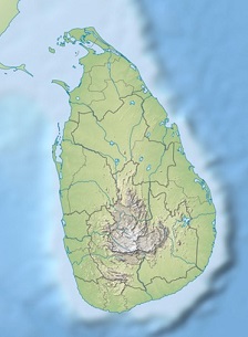
Map 1
Extreme caution has to be taken not to upset physical equilibrium set by nature by constructing large reservoirs like Kotmale reservoir on these watersheds at such a high elevation. Because one day if there is going to be a dam breach at this level, at spill level, carrying a 285 feet high 28,000,000 cu ft of water either due to natural causes or manmade actions like a LTTE terrorist attack, the resulting downstream disaster would be extremely high and unimaginable, considering the elevation of the location (2306 ft msl) of this dam in relation to the densely populated downstream settlement, the height and the enormous volume of water in the reservoir at spill level, 28,000,000 cu ft and the relative cumulative gravitational force the flood will acquire as it role down roaring over the hills and valleys will be definitely beyond human imagination. If a breach takes place this could be ranked as the world’s most disastrous dam breach tragedy in history. This danger becomes all the more serious in view of the relative location of the reservoir at very high level, the abrupt drop in the elevation and the peculiar radial geomorphological lay out of the Island in relation to the location of the Kotmale reservoir as shown in the map1.
Under these circumstances if the dam breaches due to any reason the enormous volume of water that it empties will roar down the precipice of Kotmale Oya will be extremely devastative with its thundering high tide pouring in to Mahaweli. First it will scoop out Gampola and Gelioya towns together with the rich Kandyan agricultural villages on either side of Mahaweli and once it reaches Peradeniya it will get split in to three massive floods, one turning left at Peradeniya. and another urning right at Getambe while the main flood will go down Mahaweli up to Katugagastota, where it will again bifurcate in to two, the left flood will force up Pingaoya and go towards Matale and the main one, erasing Katugastoa, sweeping Polgolla barrage will surge in to Victoria reservoir. The third flood that will takes its course along the Peradeniya Kandy road and then scooping Kandy town and pouring in to Victoria Reservoir over Buwelikada gap taking a part of Udawatta kele together with the debris of the historic Mahanwara Town together with the Temple of the Tooth with all its sacred and mundane treasures to be deposited in the depth of the Indian Ocean.This will then join the flood coming down Polgolla and together it will get reinforced with the Victoria waters (722,000.000 m2)_ and then
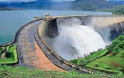
VICTORIA DAM
burst in to Randenigala (647,000,000 cu ft) and finally collecting 361,446 Cu ft of Rantembe with the debris of all the Dams will end up in the Eastern Sea with all what this mighty surge will scoop out from the Eastern province and what it has already collected from either side of the Mahaweli river from Kotmale downward, say up to about hundreds of feet on either side up to end of Rantembe, the last reservoir on the Mahaweli, carving out a huge canyon up to the sea. You can just imagine the thrust of the total volume of water that will scoop out almost 2/3 of the Eastern Province in an open funnel shape cavity in to the Indian Ocean.
Meanwhile the one that go down the Kumbiyangoda precipice will scoop out the Matale town, empties the Nalanda Reservoir and the Moragakha kanda, with its 521,000,000 m3 and will erase what is left out by the main flood that comes down the main Mahaweli and also that is surging in to the eastern flat land at its bend near old Minipe anicut site. The Matale Moragahakanda flood will take the balance of the eastern Province to the Indian Ocean, with the Polonnaruwa town and all the sacred treasures standing in the Polonnaruwa kingdom along with the waters of the Parakrama Samudra(112,500 acre feet).
Finally, the flood that go across Kiribath kumbura and Kadugannava down the precipice to Mavanella will scoop out the areas on either side of the Ma Oya from there onwards and empties in to the Indian Ocean on the western side of the Island around Negambo.
Now you will see how Sri Lanka will end up in three huge permanent canyons like scars from Kotmale to the Indian ocean on either sides of the central axis running north from the central hill country, dividing the Sinhale in to three parts (remnants of the old 3 Sinhale with a major part of the Malayarata} like a huge canyon of the Colarado canyon type with a central axis starting at Kotmale in the Central hill country of Sri Lanka.
I also suggest that you have a look at the disasters caused by similar dam breaches that have taken place in other countries.to imagine how such dam breaches have affected human life in those countries. For example, dam breach studies in countries like USA, (the johnston town flood 1989), Italy, (Vaiont Dam 1963) and India, (Tiwari Dam failure in Maharastra) to understand the national danger I am talking about in this paper.
If this breach takes place I think it could be the worst dam breach in the world in known history, forming a huge canyon looking like a fork with 3 prongs with its handle in the south that had erased a whole civilization that was the ancient Kandyan Kingdom.
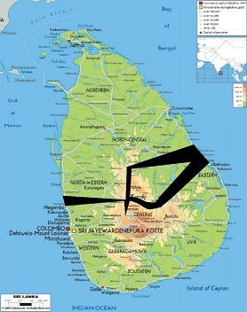
MAP 2
GRAPHIC IMAGINATION of man made SRI LANKAN CANYONS
Sudath Gunasekara
It is in this backdrop Mr Gotahbhaya that I appeal to you to take the maximum precautionary action in time to prevent this historic national catastrophe.
Any delay on your part as Defense Secretary to take adequate precautionary measures will put the blame squarely on you for outright negligence, if the Kotmale dam breaks due to an attack by the LTTE.
I only hope by providence of God, they will not attack it. Let us all pray for it
PS: I am writing this note almost 16 years after I addressed this note to Gotabhaya in 2006. I am very happy that no disaster has happened so far thanks God. I warn authorities that they should not take things for grant and rest asleep. A disaster as predicted can take place at any moment in view of its location in a limestone region, particularly at such height in the center of Sri Lanka with the enormous volume of water stored in the reservoir.
Therefore, I plead to the authorities in charge of the DAM to keep a 24 hours vigil on the changes taking place so that you can take timely action at least to mitigate the scale of the disaster that might occur one day.
epilogue
Under the Mahaweli Development Project Kotmale flooded nearly 4000 ha of fertile land in the Mahaweli upper catchment, which included about 600 ha of paddy fields and has directly affected 3056 traditional Sinhala families with a legacy of a rich traditional culture who were involuntarily evacuated from their ancestral lands whose ancestors had been living there from the early Christian times, if not earlier.
Of them 1722 families were moved to downstream areas in the Dry Zone and 1334 families, which were said to be resettled in 17 settlements around the reservoir
The evacuation of such a large number of Sinhala people from an agriculturally rich historic settlement in the heartland of the nation where there is a large concentration of Indian Tamil population invariably leads to weakening the power of the native Sinhala population in the region, which will have serious political repercussions in future.
Thus, considering the immediate and long term economic, and demographic losses to a nation that is impossible to be quantified and the impending disaster for the whole nation as forecasted above, I hold the view that the construction of Kotmale dam was an unpardonable historic political blunder.